1910s Maps of Rosedale Heights Colonia, Texas
Explore 2 historic maps of Rosedale Heights Colonia from the 1910s. These maps offer a rare glimpse into what life looked like during the 1910s — showing old roads, neighborhoods, homes, and landmarks that have changed or disappeared over time.
Whether you're researching your family's past, planning a metal detecting trip, or studying how Rosedale Heights Colonia's landscape evolved across the 1910s, these high-resolution maps are a powerful tool for exploring the history of this region.
- Focus on a specific era: All maps on this page are from the 1910s, giving you a focused view of this time period.
- See what’s changed: Compare century-old streets, trails, and buildings to today's modern landscape using overlays and satellite layers.
- Research with precision: Use these maps for genealogy, historical research, land use analysis, or educational projects.
- View, download, or print: Maps are fully viewable online in high resolution, and can be downloaded or printed for your own records.
Start exploring Rosedale Heights Colonia's history through authentic maps from the 1910s. This is your window into the past.
Rosedale Heights Colonia, TX maps
(2)- 1914 Map of San Juan
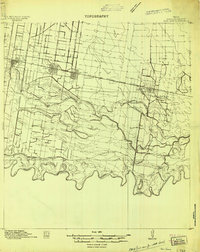 1914 San Juan1914 Print · USGSThe Lower Rio Grande Valley is captured here just before the First World War, showing the early rail-driven growth of McAllen, Pharr, and San Juan. Genealogists and historians can trace the transition from old river-side life along the Military Road to the irrigation-based settlements at Ebenezer and Valley View Plantation.2 unique versions available
 - 1916 Map of San Juan
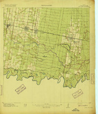 1916 San Juan1916 Print · USGSThe Lower Rio Grande Valley underwent a dramatic transformation in the mid-1910s as rail and irrigation reshaped the border. Trace the early growth of Mc Allen and Pharr or follow the historic Military Road as it winds past the Valley View Plantation.3 unique versions available
End of results
Showing maps 1-2 of 2
Top cities near Rosedale Heights Colonia
- McAllen historical maps
- Edinburg historical maps
- Harlingen historical maps
- Pharr historical maps
- Weslaco historical maps
- San Juan historical maps
See more
Frequently asked questions
- What are the different types of historical maps available for Rosedale Heights Colonia?
- What is the oldest map of Rosedale Heights Colonia?
- Where can I purchase historical maps of Rosedale Heights Colonia for my home or office?
- Where can I download high-res historical maps of Rosedale Heights Colonia?
- Are there historical topographic maps available for Rosedale Heights Colonia?
- Is there historical aerial imagery available for Rosedale Heights Colonia?
- Where are historical maps of Rosedale Heights Colonia sourced from?