1960s Maps of Weslaco, Texas
Explore 4 historic maps of Weslaco from the 1960s. These maps offer a rare glimpse into what life looked like during the 1960s — showing old roads, neighborhoods, homes, and landmarks that have changed or disappeared over time.
Whether you're researching your family's past, planning a metal detecting trip, or studying how Weslaco's landscape evolved across the 1960s, these high-resolution maps are a powerful tool for exploring the history of this region.
- Focus on a specific era: All maps on this page are from the 1960s, giving you a focused view of this time period.
- See what’s changed: Compare century-old streets, trails, and buildings to today's modern landscape using overlays and satellite layers.
- Research with precision: Use these maps for genealogy, historical research, land use analysis, or educational projects.
- View, download, or print: Maps are fully viewable online in high resolution, and can be downloaded or printed for your own records.
Start exploring Weslaco's history through authentic maps from the 1960s. This is your window into the past.
Weslaco, TX maps
(4)- 1962 Map of Brownsville
 1962 Brownsville1962 Print · USGSThe Lower Rio Grande Valley in the early sixties was a landscape of coastal wildlands, booming oil fields, and international border commerce. Trace the development of this frontier region through landmarks like Harlingen Air Force Base, Boca Chica Island, and the Willamar Oil Field.
 - 1962 Map of McAllen
 1962 McAllen1962 Print · USGSThe Lower Rio Grande Valley in the mid-twentieth century shows a complex landscape of irrigation, oil production, and border commerce. Genealogists and historians can trace family roots through riverside towns like Zapata, Roma-Los Saenz, and Hidalgo, or locate landmarks like Santa Elena Ch and Moore Air Force Base.
 - 1962 Map of San Juan SE, 1965 Print
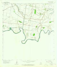 1962 San Juan SE1965 Print · USGSThe Texas-Mexico borderlands come into focus in the early sixties, showing the complex river meanders of the Rio Grande. Researchers can trace land tracts like Monterrey Banco No 89 or locate local landmarks such as Webber Cem and the Donna Pumping Station.
 - 1963 Map of Donna, 1965 Print
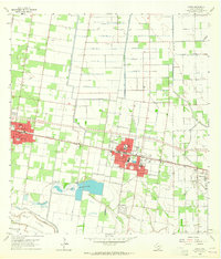 1963 Donna1965 Print · USGSThe Rio Grande Valley during the early sixties comes into focus here, showing the citrus and irrigation networks of Hidalgo County. Genealogists can locate family names at St Joseph Cem or trace early school sites like Franklin Sch and South Donna Sch.4 unique versions available
End of results
Showing maps 1-4 of 4
Top cities near Weslaco
- McAllen historical maps
- Edinburg historical maps
- Harlingen historical maps
- Pharr historical maps
- San Juan historical maps
- Alamo historical maps
See more
Top neighborhoods of Weslaco
- Anaqua Addition Colonia historical maps
- Bellaire Colonia historical maps
- West Highway Colonia historical maps
- Citrus Retreat Colonia historical maps
- Westgate Estates Colonia historical maps
- Olivarez Number 1 Colonia historical maps
See more
Frequently asked questions
- What are the different types of historical maps available for Weslaco?
- What is the oldest map of Weslaco?
- Where can I purchase historical maps of Weslaco for my home or office?
- Where can I download high-res historical maps of Weslaco?
- Are there historical topographic maps available for Weslaco?
- Is there historical aerial imagery available for Weslaco?
- Where are historical maps of Weslaco sourced from?