1960s Maps of Hill County, Texas
Explore 18 historic maps of Hill County from the 1960s. These maps offer a rare glimpse into what life looked like during the 1960s — showing old roads, neighborhoods, homes, and landmarks that have changed or disappeared over time.
Whether you're researching your family's past, planning a metal detecting trip, or studying how Hill County's landscape evolved across the 1960s, these high-resolution maps are a powerful tool for exploring the history of this region.
- Focus on a specific era: All maps on this page are from the 1960s, giving you a focused view of this time period.
- See what’s changed: Compare century-old streets, trails, and buildings to today's modern landscape using overlays and satellite layers.
- Research with precision: Use these maps for genealogy, historical research, land use analysis, or educational projects.
- View, download, or print: Maps are fully viewable online in high resolution, and can be downloaded or printed for your own records.
Start exploring Hill County's history through authentic maps from the 1960s. This is your window into the past.
Hill County, TX maps
(18)- 1961 Map of Maypearl, 1963 Print
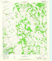
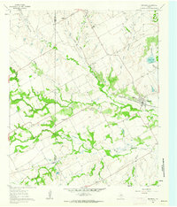 1961 Maypearl1963 Print · USGSMaypearl and the Ellis County countryside are captured here in the early sixties, showing the agricultural landscape before suburban expansion. Genealogists can trace family landmarks and rural burial sites like Auburn Cem, Odom Cem, and the rail-side community of Griffith.3 unique versions available
 - 1961 Map of Grandview, 1963 Print
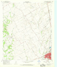
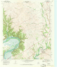
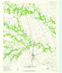 1961 Grandview1963 Print · USGSGrandview and the surrounding Johnson County prairies are captured in the early sixties as the railroad still drove the local economy. Genealogists and local historians can trace family plots at Old Hill Cem and Boatright Cem or locate the site of Antioch.2 unique versions available
 - 1965 Map of Coolidge, 1967 Print
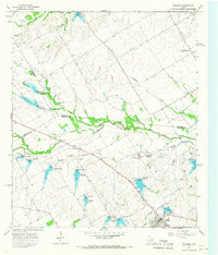 1965 Coolidge1967 Print · USGSCoolidge and the surrounding Limestone County prairie are captured here during a period of significant water management in the mid-sixties. Genealogists and local historians can trace the rural landscape through the Dover Cem and settlements like Munger or Calina.2 unique versions available
 - 1965 Map of Files Valley, 1967 Print
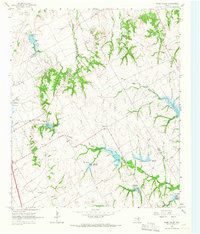 1965 Files Valley1967 Print · USGSMid-century Hill County life centers on the rural waterworks and farming settlements of the Files Valley area. Genealogists can trace family sites at Berrys Chapel Cem and Files Cem or locate the historic Presbyterian Childrens Home.2 unique versions available
 - 1965 Map of Italy, 1967 Print
 1965 Italy1967 Print · USGSIn the mid-1960s, this portion of Ellis County was a busy intersection of the Missouri Pacific and M-K-T railroads. Genealogists can trace family footprints at Bee Creek Cem, Stafford Sch, and the community of Center Point.3 unique versions available
 - 1965 Map of Frost, 1967 Print
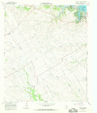
 1965 Frost1967 Print · USGSNavarro County's agricultural heartland is captured here in the mid-sixties, centered on the hub of Frost. Historians and genealogists can trace rural family roots through several local burial grounds like Blanton-Hooser Cem, Richland Cem, and Pevehouse Cem.
 - 1965 Map of Mertens, 1967 Print
 1965 Mertens1967 Print · USGSCentral Texas at the mid-century shows a landscape shaped by rail corridors and new water management. Trace family roots at the Old Brandon Cem and see the rail junctions at Mertens and Brandon before the decline of the local lines.
 - 1965 Map of Itasca, 1968 Print
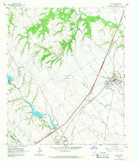
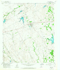
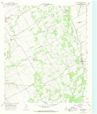
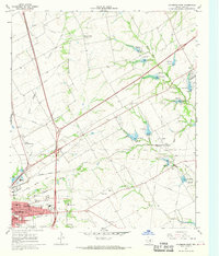
 1965 Itasca1968 Print · USGSItasca and the surrounding Hill County plains are captured here in the mid-1960s as a thriving rail and ranching community. Researchers can trace local genealogy and land use via the Missouri Kansas Texas railroad, the town Cem, and High Sch.
 - 1966 Map of Blanton, 1968 Print
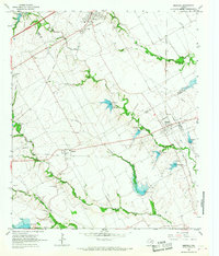
 1966 Blanton1968 Print · USGSHill County farm and ranch land meets the water in the mid-sixties, capturing a landscape of rural crossroads and new lakefront development. Trace vanished footprints at Huron and Blanton, or locate family sites near Jawbone Cem and Shiloh Ch.2 unique versions available
 - 1966 Map of Hillsboro West, 1968 Print
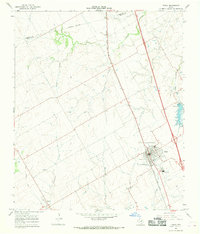
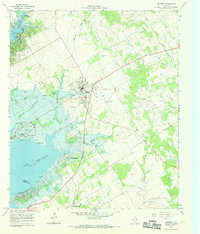
 1966 Hillsboro West1968 Print · USGSHill County is captured in the mid-sixties as the local rail and agricultural networks still defined the landscape. Genealogists and historians can trace family locations near Mayfield, locate the Woodbury Cem, or follow the Old Railroad Grade through the countryside.2 unique versions available
 - 1966 Map of Covington, 1968 Print
 1966 Covington1968 Print · USGSSpanning the Johnson and Hill County line in the mid-1960s, this survey shows a landscape of small settlements and prairie creeks. Genealogists can trace family roots through Union Hill Ch, Hart Cem, and the old rail corridor at Covington.2 unique versions available
 - 1966 Map of Hillsboro East, 1968 Print
 1966 Hillsboro East1968 Print · USGSHillsboro was transitioning into a modern regional hub in the mid-1960s, balanced between its rail-road heritage and new educational institutions. Trace the development of Hill Jr College and Katy Lake, or locate family sites near Park Ridge Cem and Love View Ch.2 unique versions available
 - 1966 Map of Whitney, 1969 Print
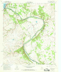
 1966 Whitney1969 Print · USGSCentral Texas life in the mid-sixties centers on the growing town of Whitney and the recreational waters of Lake Whitney. Genealogists can trace family names at Bethlehem Cem and Towash Ch or follow the path of the Old Railroad Grade.2 unique versions available
 - 1966 Map of Laguna Park, 1969 Print
 1966 Laguna Park1969 Print · USGSBosque County and the shores of the Brazos River are documented here in the mid-1960s as recreation and agriculture shaped the landscape. Genealogy and local history researchers can trace the rural communities of Womack and Cayote, or locate the Fairview Ch and old burial grounds at Cem.
 - 1966 Map of Smiths Bend, 1969 Print
 1966 Smiths Bend1969 Print · USGSThe Brazos River valley north of Waco in the mid-sixties reveals a landscape of limestone bluffs and rural settlements. Genealogists and historians can trace family sites at Smiths Bend-Coon Creek Cem or locate the old Spivey Crossing ford.2 unique versions available
 - 1968 Map of Allen Bend, 1971 Print
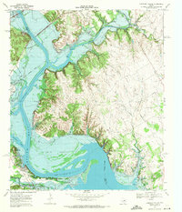
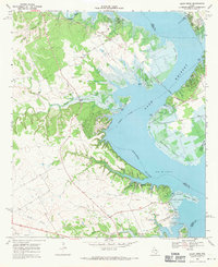 1968 Allen Bend1971 Print · USGSThe Brazos River valley transitions into a major reservoir in the late sixties as the waters of Lake Whitney reshape the Hill and Bosque county line. Genealogists can locate rural landmarks like Steiner Sch and Cedron Cem alongside the modern Lakewood Harbor.
 - 1968 Map of Lakeside Village, 1971 Print
 1968 Lakeside Village1971 Print · USGSThe Brazos and Nolan River valleys appear here just as the reservoir landscape was maturing in the late sixties. Genealogists and local historians can locate lakeside settlements like Lakeside Village and old burial grounds such as Steiner Valley Cem.2 unique versions available
 - 1968 Map of Blum, 1971 Print
 1968 Blum1971 Print · USGSThe Hill County landscape is captured in the late sixties as Lake Whitney reshapes the Brazos valley. Genealogists and historians can trace the Chisholm Trail, locate the Grange Hall Cem, and study the rail corridor through Blum.2 unique versions available
End of results
Showing maps 1-18 of 18
Top cities of Hill County
- Hillsboro historical maps
- Whitney historical maps
- Itasca historical maps
- Hubbard historical maps
- Blum historical maps
- Abbott historical maps
See more
Frequently asked questions
- What are the different types of historical maps available for Hill County?
- What is the oldest map of Hill County?
- Where can I purchase historical maps of Hill County for my home or office?
- Where can I download high-res historical maps of Hill County?
- Are there historical topographic maps available for Hill County?
- Is there historical aerial imagery available for Hill County?
- Where are historical maps of Hill County sourced from?