1920s Maps of Blum, Texas
Explore 2 historic maps of Blum from the 1920s. These maps offer a rare glimpse into what life looked like during the 1920s — showing old roads, neighborhoods, homes, and landmarks that have changed or disappeared over time.
Whether you're researching your family's past, planning a metal detecting trip, or studying how Blum's landscape evolved across the 1920s, these high-resolution maps are a powerful tool for exploring the history of this region.
- Focus on a specific era: All maps on this page are from the 1920s, giving you a focused view of this time period.
- See what’s changed: Compare century-old streets, trails, and buildings to today's modern landscape using overlays and satellite layers.
- Research with precision: Use these maps for genealogy, historical research, land use analysis, or educational projects.
- View, download, or print: Maps are fully viewable online in high resolution, and can be downloaded or printed for your own records.
Start exploring Blum's history through authentic maps from the 1920s. This is your window into the past.
Blum, TX maps
(2)- 1924 Map of Cleburne 3-B
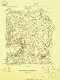 1924 Cleburne 3-B1924 Print · USGSNorth of the Brazos River in the mid-1920s, this area shows a landscape of rural schools and winding creek hollows. Genealogists and historians can trace the early rail influence through Rio Vista and Blum or find family-named landmarks like Klondike Ranch and Plain View School.
 - 1927 Map of Blum
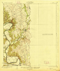 1927 Blum1927 Print · USGSThe Brazos River valley and the rail towns of Hill and Bosque Counties are captured here in the mid-twenties. Genealogists can trace rural landmarks like Plainview School, Heath Cem, and historic river fords like Ft Graham Crossing.2 unique versions available
End of results
Showing maps 1-2 of 2
Top cities near Blum
- Cleburne historical maps
- Alvarado historical maps
- Whitney historical maps
- Grandview historical maps
- Rio Vista historical maps
- Morgan historical maps
See more
Frequently asked questions
- What are the different types of historical maps available for Blum?
- What is the oldest map of Blum?
- Where can I purchase historical maps of Blum for my home or office?
- Where can I download high-res historical maps of Blum?
- Are there historical topographic maps available for Blum?
- Is there historical aerial imagery available for Blum?
- Where are historical maps of Blum sourced from?