1950s Maps of Mount Calm, Texas
Explore 5 historic maps of Mount Calm from the 1950s. These maps offer a rare glimpse into what life looked like during the 1950s — showing old roads, neighborhoods, homes, and landmarks that have changed or disappeared over time.
Whether you're researching your family's past, planning a metal detecting trip, or studying how Mount Calm's landscape evolved across the 1950s, these high-resolution maps are a powerful tool for exploring the history of this region.
- Focus on a specific era: All maps on this page are from the 1950s, giving you a focused view of this time period.
- See what’s changed: Compare century-old streets, trails, and buildings to today's modern landscape using overlays and satellite layers.
- Research with precision: Use these maps for genealogy, historical research, land use analysis, or educational projects.
- View, download, or print: Maps are fully viewable online in high resolution, and can be downloaded or printed for your own records.
Start exploring Mount Calm's history through authentic maps from the 1950s. This is your window into the past.
Mount Calm, TX maps
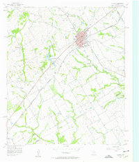
(5)- 1954 Map of Waco, 1964 Print
 1954 Waco1964 Print · USGSCentral Texas during the mid-fifties shows a landscape defined by the expansion of Fort Hood Military Reservation and the Brazos river system. Trace the rail lines and early airfields like James Connally Air Force Base and settlements like Temple or McGregor.2 unique versions available
 - 1955 Map of Waco
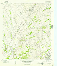
 1955 Waco1955 Print · USGSCentral Texas at the peak of the Cold War reveals a landscape defined by military expansion and major water projects. Researchers can trace the footprints of Fort Hood, the waters of Lake Waco, and regional hubs like Temple or Mexia.
 - 1956 Map of Hubbard
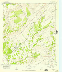
 1956 Hubbard1956 Print · USGSHubbard and the surrounding Blackland Prairie country are captured here in the mid-1950s as a vital railroad and farming hub. Genealogists can locate several rural burial grounds, including Fairview Cemetery and Valley View Cem, alongside the Phyllis Wheatly Sch.3 unique versions available
 - 1956 Map of Penelope, 1957 Print
 1956 Penelope1957 Print · USGSThe Blackland Prairie of Hill and McLennan Counties was deeply tied to the Missouri Pacific railroad in the mid-fifties. Genealogists can trace family footprints through numerous rural burial sites like the Czech National Cem, Tabola Cem, and George Newton Cem.2 unique versions available
 - 1956 Map of Axtell, 1957 Print
 1956 Axtell1957 Print · USGSMid-century McLennan and Hill counties appear here at a busy rail-and-creek intersection just before significant modernization. Genealogists can trace rural family roots at TK Cem or Shead Cem, and follow the St Louis Southwestern rail line through Axtell.2 unique versions available
End of results
Showing maps 1-5 of 5
Top cities near Mount Calm
- Waco historical maps
- Bellmead historical maps
- Hillsboro historical maps
- Lacy Lakeview historical maps
- West historical maps
- Mart historical maps
See more
Frequently asked questions
- What are the different types of historical maps available for Mount Calm?
- What is the oldest map of Mount Calm?
- Where can I purchase historical maps of Mount Calm for my home or office?
- Where can I download high-res historical maps of Mount Calm?
- Are there historical topographic maps available for Mount Calm?
- Is there historical aerial imagery available for Mount Calm?
- Where are historical maps of Mount Calm sourced from?