1900s (20th Century) Maps of Sulphur Springs, Texas
Explore 8 historic maps of Sulphur Springs from the 1900s (20th Century). These maps offer a rare glimpse into what life looked like during the 1900s — showing old roads, neighborhoods, homes, and landmarks that have changed or disappeared over time.
Whether you're researching your family's past, planning a metal detecting trip, or studying how Sulphur Springs's landscape evolved across the 1900s, these high-resolution maps are a powerful tool for exploring the history of this region.
- Focus on a specific era: All maps on this page are from the 1900s, giving you a focused view of this time period.
- See what’s changed: Compare century-old streets, trails, and buildings to today's modern landscape using overlays and satellite layers.
- Research with precision: Use these maps for genealogy, historical research, land use analysis, or educational projects.
- View, download, or print: Maps are fully viewable online in high resolution, and can be downloaded or printed for your own records.
Start exploring Sulphur Springs's history through authentic maps from the 1900s. This is your window into the past.
Sulphur Springs, TX maps
(8)- 1953 Map of Texarkana, 1964 Print
 1953 Texarkana1964 Print · USGSThe Texas-Arkansas borderlands are captured here in the mid-fifties, during a decade of massive military and hydraulic engineering projects. Genealogists and researchers can locate family landmarks like Old Boston Cem, Siloam Ch, and the vast Red River Arsenal.4 unique versions available
 - 1956 Map of Texarkana
 1956 Texarkana1956 Print · USGSThe Ark-La-Tex borderlands come alive in the mid-fifties, showing the transition from a rail-dependent rural economy to a post-war industrial landscape. Researchers can trace the massive Red River Ordnance Depot and find towns like Talco, Bogata, and Naples.
 - 1962 Map of Brashear, 1966 Print
 1962 Brashear1966 Print · USGSHopkins County in the early sixties reveals a landscape of tight-knit rural communities and emerging water management systems. Genealogists and local historians can trace the foundations of Brashear, Shirley, and Rockdale, including specific locations for Rockdale Ch and Greenview Ch.
 - 1964 Map of Sulphur Springs, 1968 Print
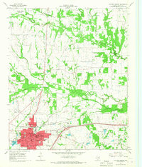 1964 Sulphur Springs1968 Print · USGSSulphur Springs and its rural environs are captured in the mid-1960s, showing a landscape defined by the St Louis Southwestern railroad and numerous country churches. Genealogists and researchers can trace family-named sites like Beckham Ch, Old Tarrant Ch, and the Odd Fellows Cem.
 - 1964 Map of Gafford Chapel, 1968 Print
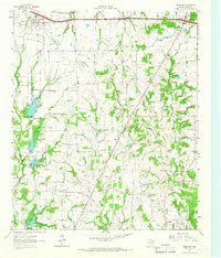
 1964 Gafford Chapel1968 Print · USGSHopkins County, Texas, is captured here in the mid-1960s as a landscape of rural communities and vital rail lines. Genealogists and researchers can trace local landmarks like Gafford Chapel, Webb, and the old Drive-in Theater near the railroad junctions.
 - 1964 Map of Sulphur Springs SE, 1968 Print
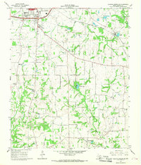 1964 Sulphur Springs SE1968 Print · USGSThe southeastern corner of Hopkins County in the mid-1960s reveals a network of rural communities and rail-side industry. Genealogists and local historians can trace family-named sites like Mc Keever, old burial grounds like Gamblin Cem, and the quiet community of Reilly Springs.2 unique versions available
 - 1985 Map of Sulphur Springs
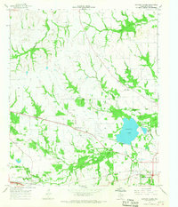
 1985 Sulphur Springs1985 Print · USGSNortheast Texas in the mid-eighties shows a landscape transitioning between its deep-rooted rail towns and a new era of reservoir development. Genealogists and historians can trace family locations near Shooks Chapel, the rural Farmers Academy, and the banks of the South Sulphur River.
 - 1991 Map of Sulphur Springs
 1991 Sulphur Springs1991 Print · USGSNortheast Texas in the early nineties shows a transition from rail-dependent agriculture to a landscape defined by massive reservoirs. Researchers can trace rural lineages through sites like Gafford Chapel and the Forest Academy Cem, or follow the path of the St Louis Southwestern RR.
End of results
Showing maps 1-8 of 8
Top cities near Sulphur Springs
- Cooper historical maps
- Cumby historical maps
- Como historical maps
- Yantis historical maps
- Tira historical maps
Top neighborhoods of Sulphur Springs
Frequently asked questions
- What are the different types of historical maps available for Sulphur Springs?
- What is the oldest map of Sulphur Springs?
- Where can I purchase historical maps of Sulphur Springs for my home or office?
- Where can I download high-res historical maps of Sulphur Springs?
- Are there historical topographic maps available for Sulphur Springs?
- Is there historical aerial imagery available for Sulphur Springs?
- Where are historical maps of Sulphur Springs sourced from?