Old Maps of Houston County, Texas
Explore 227 old maps of Houston County, spanning from 1946 to today. These high-resolution historic maps reveal how streets, neighborhoods, landmarks, and natural features evolved over time — perfect for genealogy, metal detecting, research, and local history exploration.
What you can do with these maps:
- See how Houston County changed over time: Compare historical maps to modern-day views to trace roads, homesites, rail lines & more.
- View detailed metadata: Each map includes creators, publishers, year, scale, and archive source.
- Overlay maps with satellite & LiDAR: Visualize the past alongside modern tools to explore terrain & human change.
- Trusted historical sources: Maps sourced from the USGS, Library of Congress, and other archives.
- Access maps your way: View online, download high-res files, or order prints for personal or research use.
Start exploring old maps of Houston County to uncover forgotten places, hidden landmarks, and the deep history beneath your feet.
Houston County, TX maps
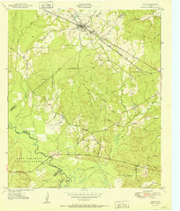
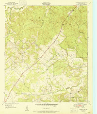
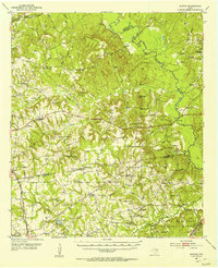
(227)- 1946 Map of Alto
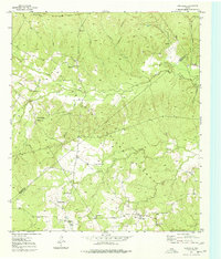
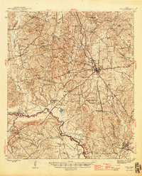 1946 Alto1946 Print · USGSEast Texas at the end of World War II reveals a landscape deeply connected to its frontier origins, anchored by Alto and the Neches River. Genealogists and historians can trace local landmarks like the Bowles Monument, Central High Sch, and the Site of Ft Lacy along the historic El Camino Real.2 unique versions available
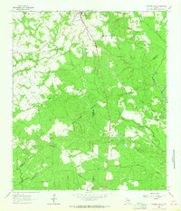
 - 1950 Map of Crockett, 1965 Print
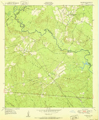
 1950 Crockett1965 Print · USGSCrockett and its rural surroundings are captured here at mid-century as the town expanded around the Missouri Pacific rail line. Genealogists can trace family landmarks like Pearson Chapel Sch, the Old Stagecoach Inn, and Huxley Cem.
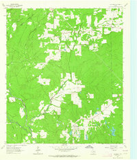
 - 1950 Map of Crockett NE, 1967 Print
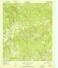
 1950 Crockett NE1967 Print · USGSEast Texas timberland and small community life are captured in the mid-century as the Old Antonio Road cuts through the forest. Researchers can locate rural landmarks like Glover Sch, Grounds Cem, and the settlement of Belott.2 unique versions available
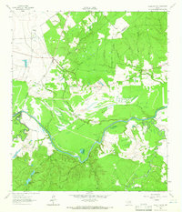
 - 1950 Map of Kennard NE, 1973 Print
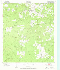
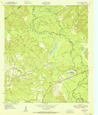
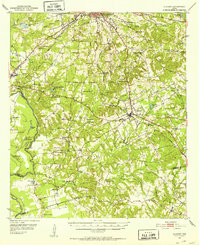
 1950 Kennard NE1973 Print · USGSEast Texas timber country comes into focus in this mid-century survey of the Neches River valley at the edge of the Crockett National Forest. Genealogists and historians can trace the foundations of rural life through the Shooks Bluff Cem, Sweet Union Ch, and the winding paths of an Old Railroad Grade.2 unique versions available
 - 1950 Map of Ratcliff, 1975 Print
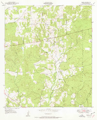
 1950 Ratcliff1975 Print · USGSHouston County at the mid-century was a landscape of dense piney woods and quiet rural outposts. Researchers can trace family sites at Bethel Cem or Conner Cem, and locate long-standing communities like Tadmor and Creath.
 - 1950 Map of Centralia, 1977 Print
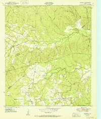
 1950 Centralia1977 Print · USGSThe Piney Woods of Trinity and Houston Counties are revealed here at mid-century as a landscape defined by timber and tight-knit rural communities. You can trace the Logging Railroad networks and find family landmarks like Rice Cem, Nogalus, and Old Ivy Ch.
 - 1951 Map of Crockett
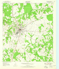
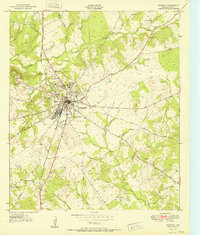 1951 Crockett1951 Print · USGSCrockett and its rural Houston County surroundings are captured here in the early fifties, centered on the junction of historic trails and rails. Genealogists can trace family landmarks like the Old Stagecoach Inn, Mary Allen College, and rural burial grounds such as Hopley Cem.
 - 1951 Map of Kennard
 1951 Kennard1951 Print · USGSDeep in the East Texas piney woods in the early fifties, this area shows the intersection of the Davy Crockett National Forest and local timber life. Genealogists can trace early landmarks like Antioch Cem, Nogalus Lookout Tower, and rural congregations including Mt Olive Ch.
 - 1951 Map of Grapeland
 1951 Grapeland1951 Print · USGSHouston County in the early fifties is captured here as a landscape of small churches and family burial plots. Local historians can trace the Missouri Pacific rail line through Grapeland and find dozens of sites like New Salem Cem and Latexo School.3 unique versions available
 - 1951 Map of Wells
 1951 Wells1951 Print · USGSCherokee County at mid-century shows a landscape shaped by timber and rail as the Piney Woods met the Neches River. Researchers can locate family landmarks like Simpson Cem, the rural center of Redtown, and the St Louis Southwestern Railroad line.3 unique versions available
 - 1951 Map of Wells SW
 1951 Wells SW1951 Print · USGSDeep East Texas timberlands come alive in this mid-century survey of the Neches River bottomlands at the edge of the Davy Crockett National Forest. Genealogists and historians can trace old transit lines like the Old Logging Railroad Grade or locate rural landmarks such as Raville Siding and Vair.3 unique versions available
 - 1951 Map of Centralia
 1951 Centralia1951 Print · USGSEast Texas timber country comes alive in the early fifties, showing the intersections of the Davy Crockett National Forest and local homesteads. Researchers can locate remote community hubs like Nogalus, Old Ivy Ch, and the defunct Logging Railroad Grade.
 - 1951 Map of Berea
 1951 Berea1951 Print · USGSHouston County at the start of the 1950s shows a landscape defined by the timbered ridges of the Davy Crockett National Forest. Genealogists can locate family landmarks like English Cem and rural centers such as Berea and Hopewell.
 - 1951 Map of Crockett NE
 1951 Crockett NE1951 Print · USGSNortheast Houston County in the early fifties is shown as a landscape of timber and rural homesteads. Genealogists can locate family landmarks such as Parker Cem and Grounds Cem or trace the path of the historic Old San Antonio Trail.
 - 1951 Map of Kennard NE
 1951 Kennard NE1951 Print · USGSEast Texas timber country and forest life are captured here in the early fifties as logging operations shaped the Houston County landscape. Genealogists and historians can trace the Old Railroad Grade, locate the Shooks Bluff Cem, and find rural landmarks like Plain Ch and Wells Sch.
 - 1951 Map of Ratcliff
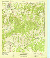
 1951 Ratcliff1951 Print · USGSHouston County at the start of the 1950s was a landscape of deep timber and small forest communities within the Davy Crockett National Forest. Researchers can locate family landmarks such as Tadmor Ch, Old Zion Cem, and the old settlement at Ratcliff.
 - 1951 Map of Elkhart, 1952 Print
 1951 Elkhart1952 Print · USGSEast Texas ranching and oil communities thrive along the river bottoms in the early fifties. Genealogists can trace family roots through numerous rural landmarks like Fort Houston Cem, Myrtle Springs Sch, and Old Salt Works Lake.2 unique versions available
 - 1952 Map of Slocum, 1953 Print
 1952 Slocum1953 Print · USGSEast Texas timber and creek country comes alive in the early fifties, showing the rural landscapes of Anderson and Houston counties. Genealogists can locate family sites and pioneer burials at Union Hope Sch & Cem, Livelyville Ch (Cem), and Mound City.2 unique versions available
 - 1953 Map of Palestine, 1964 Print
 1953 Palestine1964 Print · USGSEast Texas was defined by its deep pine forests and burgeoning energy sector in the mid-1950s. Genealogists and historians can trace the rail-and-river economy through settlements like Tennessee Colony and Pollok or explore the early footprints of the Cayuga Oil Field and Davy Crockett National Forest.2 unique versions available
 - 1954 Map of Beaumont, 1964 Print
 1954 Beaumont1964 Print · USGSSoutheast Texas in the mid-fifties reveals a landscape of massive national forests, emerging reservoirs, and a booming oil economy. Genealogists and researchers can trace rural settlements like Dallardsville and Village Mills or locate early drilling sites at Sour Lake Oil Field.3 unique versions available
 - 1957 Map of Beaumont
 1957 Beaumont1957 Print · USGSSoutheast Texas in the mid-fifties is defined by the timber-rich lands between the Trinity River and Beaumont. Trace the history of the Alabama and Coushatti Indian Reservation or locate early campus sites like Prairie View College.
 - 1957 Map of Palestine
 1957 Palestine1957 Print · USGSEast Texas in the mid-fifties reveals a landscape of deep pine forests and winding river valleys before the era of massive reservoir construction. Researchers can trace the legacy of the timber and rail industries through labels for the Missouri Pacific RR, Davy Crockett National Forest, and Nacogdoches.
 - 1962 Map of Lovelady South, 1964 Print
 1962 Lovelady South1964 Print · USGSThe woodlands of East Texas are captured here in the early 1960s as a landscape of timber, oil, and rail. Genealogists can locate family landmarks like Prairie Pt Cem, White Rock Ch, and the workings of the Trinity Oil Field.
 - 1962 Map of Glendale, 1964 Print
 1962 Glendale1964 Print · USGSDeep in East Texas during the early sixties, this area shows the rural life of Trinity and Houston Counties. Genealogists can trace family names at Holly Cem, Thompson Sch, and Zion Hill Ch, or follow the Old Railroad Grade past Glendale.2 unique versions available
 - 1962 Map of Wyser Bottom, 1965 Print
 1962 Wyser Bottom1965 Print · USGSThe Trinity River valley in the early 1960s reveals a landscape of oxbow lakes and riverine bluffs. Genealogists can trace family landmarks like Spivey Cem, Mason Cem, and the rural New Hope Ch near the settlement of Whites.2 unique versions available
Showing maps 1-25 of 227
Top cities of Houston County
- Crockett historical maps
- Grapeland historical maps
- Lovelady historical maps
- Kennard historical maps
- Latexo historical maps
- Hickory Creek historical maps
Frequently asked questions
- What are the different types of historical maps available for Houston County?
- What is the oldest map of Houston County?
- Where can I purchase historical maps of Houston County for my home or office?
- Where can I download high-res historical maps of Houston County?
- Are there historical topographic maps available for Houston County?
- Is there historical aerial imagery available for Houston County?
- Where are historical maps of Houston County sourced from?