1960s Maps of Houston County, Texas
Explore 17 historic maps of Houston County from the 1960s. These maps offer a rare glimpse into what life looked like during the 1960s — showing old roads, neighborhoods, homes, and landmarks that have changed or disappeared over time.
Whether you're researching your family's past, planning a metal detecting trip, or studying how Houston County's landscape evolved across the 1960s, these high-resolution maps are a powerful tool for exploring the history of this region.
- Focus on a specific era: All maps on this page are from the 1960s, giving you a focused view of this time period.
- See what’s changed: Compare century-old streets, trails, and buildings to today's modern landscape using overlays and satellite layers.
- Research with precision: Use these maps for genealogy, historical research, land use analysis, or educational projects.
- View, download, or print: Maps are fully viewable online in high resolution, and can be downloaded or printed for your own records.
Start exploring Houston County's history through authentic maps from the 1960s. This is your window into the past.
Houston County, TX maps
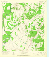
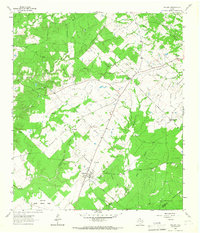
(17)- 1962 Map of Lovelady South, 1964 Print
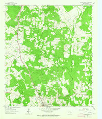
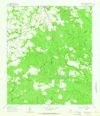 1962 Lovelady South1964 Print · USGSThe woodlands of East Texas are captured here in the early 1960s as a landscape of timber, oil, and rail. Genealogists can locate family landmarks like Prairie Pt Cem, White Rock Ch, and the workings of the Trinity Oil Field.
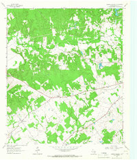
 - 1962 Map of Glendale, 1964 Print
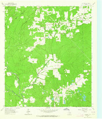 1962 Glendale1964 Print · USGSDeep in East Texas during the early sixties, this area shows the rural life of Trinity and Houston Counties. Genealogists can trace family names at Holly Cem, Thompson Sch, and Zion Hill Ch, or follow the Old Railroad Grade past Glendale.2 unique versions available
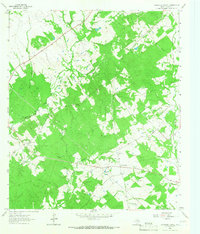
 - 1962 Map of Wyser Bottom, 1965 Print
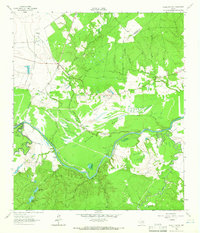 1962 Wyser Bottom1965 Print · USGSThe Trinity River valley in the early 1960s reveals a landscape of oxbow lakes and riverine bluffs. Genealogists can trace family landmarks like Spivey Cem, Mason Cem, and the rural New Hope Ch near the settlement of Whites.2 unique versions available
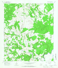
 - 1962 Map of Baker Lake, 1966 Print
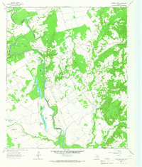
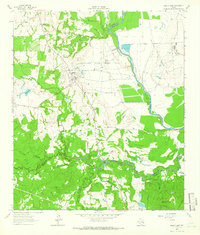 1962 Baker Lake1966 Print · USGSIn the early sixties, the Trinity River bottomlands were defined by massive agricultural institutions and quiet rural hamlets. Researchers can trace the roots of local communities at Shaw Prairie Ch, Bucks Cem, and the old settlement at Bald Prairie.2 unique versions available
 - 1963 Map of Lovelady North, 1964 Print
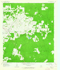
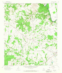
 1963 Lovelady North1964 Print · USGSHouston County at the start of the sixties reveals a landscape of rural schoolhouses and family-named cemeteries linked by the Missouri Pacific rail line. Genealogists can trace family footprints at Evergreen Cem, Center Grove Sch, and Anderson Chapel.
 - 1963 Map of Pennington, 1964 Print
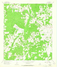
 1963 Pennington1964 Print · USGSPennington and the surrounding Piney Woods are captured in the early sixties as rural life centered on the local timberlands and country churches. Genealogists can locate family burial sites at Pennington Cem and Possum Walk Cem or trace the old paths near Friendship.2 unique versions available
 - 1963 Map of Fodice, 1965 Print
 1963 Fodice1965 Print · USGSThe piney woods and crossroads of East Texas appear in the early sixties, showing a landscape defined by timber and agriculture. Trace old family sites and rural landmarks like Fodice Cem, White Rock Ch, and the settlement of Shady Grove.2 unique versions available
 - 1964 Map of Sand Ridge, 1967 Print
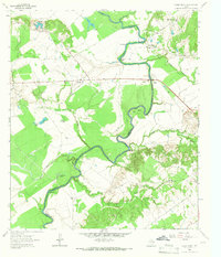
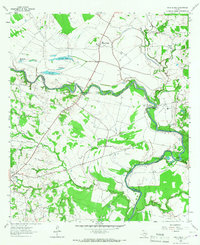 1964 Sand Ridge1967 Print · USGSThe Trinity River valley in the mid-1960s shows a landscape of rural Texas settlements and river bottomlands. Genealogists can locate family landmarks like Boatman Cem, Union Grove Ch, and the grounds of the Eastham State Prison Farm.3 unique versions available
 - 1964 Map of Austonio, 1967 Print
 1964 Austonio1967 Print · USGSHouston County in the mid-1960s was a landscape of small agricultural hamlets and timbered ridges along the river. Genealogists can trace family roots through numerous rural landmarks like Monticello Cem, Mt Zion Ch, and the settlement of Austonio.2 unique versions available
 - 1964 Map of Porter Springs, 1967 Print
 1964 Porter Springs1967 Print · USGSHouston County in the mid-sixties remained a landscape of rural communities and wooded bayous. Researchers can trace family history through the numerous rural burial grounds like Mayes Cem and Porter Springs Cem or locate the Williams High Sch.2 unique versions available
 - 1964 Map of Pearsons Chapel, 1967 Print
 1964 Pearsons Chapel1967 Print · USGSHouston County was a landscape of small churches and winding creek bottoms in the mid-sixties. Researchers can trace rural landmarks like Pearsons Chapel, Georgia Camp Ch, and the Bynum Cem alongside early Oil Wells.
 - 1964 Map of Middleton, 1967 Print
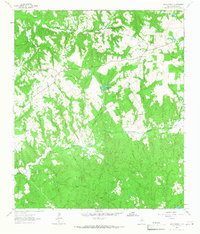
 1964 Middleton1967 Print · USGSEastern Leon County during the mid-1960s was a landscape of small creek-side settlements and crossroads communities. Genealogists and local historians can trace family locations through landmarks like Spillers Store, the Thomason Cem, and Mount Airy Ch.3 unique versions available
 - 1964 Map of Weldon, 1967 Print
 1964 Weldon1967 Print · USGSHouston County in the mid-sixties shows a landscape of rural post offices and small settlements. Genealogists can trace family landmarks at Hazel Chapel, Antioch Ch, or Salem Cem, while an Old RR Grade reveals the path of former rail transport.2 unique versions available
 - 1964 Map of Halls Bluff, 1967 Print
 1964 Halls Bluff1967 Print · USGSThe Trinity River valley along the Houston and Leon county line is shown here in the mid-sixties. Researchers can trace the rural communities of Malvern and Wheeler Springs or locate family landmarks like Smith Cem and Union Prairie Ch.2 unique versions available
 - 1964 Map of Hays Spring, 1967 Print
 1964 Hays Spring1967 Print · USGSHouston County’s rural landscapes are shown in detail during the mid-sixties, focusing on the wooded creek bottoms of the Elkhart basin. Genealogists can trace several local landmarks including Hays Spring Cem, Old Mt Zion Ch, and the McCann Cem.
 - 1964 Map of Elwood, 1967 Print
 1964 Elwood1967 Print · USGSMadison County's river-border country is captured here in the mid-1960s as the Trinity River winds past rural homesteads. Local researchers can trace family landmarks like the Alphie Cem, the settlement at Old Elwood, and the community hub at Midway.2 unique versions available
 - 1964 Map of Stanmire Lake, 1967 Print
 1964 Stanmire Lake1967 Print · USGSThe Trinity River bottomlands of East Texas are captured here in the mid-1960s, showing a landscape defined by oxbow lakes and the Navarro Crossing Oil Field. Researchers can trace the rural communities of Wheeler Springs and Reynard alongside landmarks like Shiloh Church and Bluff Cemetery.2 unique versions available
End of results
Showing maps 1-17 of 17
Top cities of Houston County
- Crockett historical maps
- Grapeland historical maps
- Lovelady historical maps
- Kennard historical maps
- Latexo historical maps
- Hickory Creek historical maps
Frequently asked questions
- What are the different types of historical maps available for Houston County?
- What is the oldest map of Houston County?
- Where can I purchase historical maps of Houston County for my home or office?
- Where can I download high-res historical maps of Houston County?
- Are there historical topographic maps available for Houston County?
- Is there historical aerial imagery available for Houston County?
- Where are historical maps of Houston County sourced from?