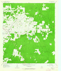
1963 Map of Pennington
USGS Topo · Published 1964About this map
Davy Crockett National Forest dominates this East Texas landscape, where the boundary between Houston and Trinity counties cuts through the timberlands and small rural clearings. The community of Pennington serves as the primary hub, surrounded by a network of family and community landmarks that speak to the area's mid-century rural character. Local life centers on several small country congregations, including Cross Roads Ch, Antioch Ch, and East Prairie Ch, while family history is anchored at the Pennington Cem and Possum Walk Cem.
Find a feature on this map
19 named features on this map. Tap any name to fly to it.
Don’t see what you’re looking for? This feature index may not catch every label — zoom into the map to look around manually.
Map Details
Editions of this 1963 Pennington Map
2 editions found
Other maps of this area

1950 · Centralia
USGS Topo · 1:24,000

1951 · Kennard
USGS Topo · 1:24,000

1951 · Centralia
USGS Topo · 1:24,000

1951 · Berea
USGS Topo · 1:24,000

1953 · Palestine
USGS Topo · 1:250,000

1957 · Palestine
USGS Topo · 1:250,000

1962 · Glendale
USGS Topo · 1:24,000

1963 · Crecy
USGS Topo · 1:24,000

1963 · Groveton West
USGS Topo · 1:24,000

1963 · Groveton East
USGS Topo · 1:24,000