1960s Maps of Lovelady, Texas
Explore 2 historic maps of Lovelady from the 1960s. These maps offer a rare glimpse into what life looked like during the 1960s — showing old roads, neighborhoods, homes, and landmarks that have changed or disappeared over time.
Whether you're researching your family's past, planning a metal detecting trip, or studying how Lovelady's landscape evolved across the 1960s, these high-resolution maps are a powerful tool for exploring the history of this region.
- Focus on a specific era: All maps on this page are from the 1960s, giving you a focused view of this time period.
- See what’s changed: Compare century-old streets, trails, and buildings to today's modern landscape using overlays and satellite layers.
- Research with precision: Use these maps for genealogy, historical research, land use analysis, or educational projects.
- View, download, or print: Maps are fully viewable online in high resolution, and can be downloaded or printed for your own records.
Start exploring Lovelady's history through authentic maps from the 1960s. This is your window into the past.
Lovelady, TX maps
(2)- 1962 Map of Lovelady South, 1964 Print
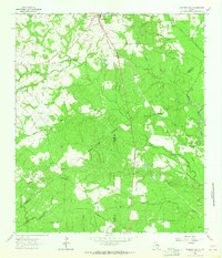 1962 Lovelady South1964 Print · USGSThe woodlands of East Texas are captured here in the early 1960s as a landscape of timber, oil, and rail. Genealogists can locate family landmarks like Prairie Pt Cem, White Rock Ch, and the workings of the Trinity Oil Field.
 - 1963 Map of Lovelady North, 1964 Print
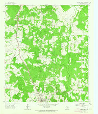 1963 Lovelady North1964 Print · USGSHouston County at the start of the sixties reveals a landscape of rural schoolhouses and family-named cemeteries linked by the Missouri Pacific rail line. Genealogists can trace family footprints at Evergreen Cem, Center Grove Sch, and Anderson Chapel.
End of results
Showing maps 1-2 of 2
Top cities near Lovelady
Frequently asked questions
- What are the different types of historical maps available for Lovelady?
- What is the oldest map of Lovelady?
- Where can I purchase historical maps of Lovelady for my home or office?
- Where can I download high-res historical maps of Lovelady?
- Are there historical topographic maps available for Lovelady?
- Is there historical aerial imagery available for Lovelady?
- Where are historical maps of Lovelady sourced from?