1970s Maps of Coahoma, Texas
Explore 2 historic maps of Coahoma from the 1970s. These maps offer a rare glimpse into what life looked like during the 1970s — showing old roads, neighborhoods, homes, and landmarks that have changed or disappeared over time.
Whether you're researching your family's past, planning a metal detecting trip, or studying how Coahoma's landscape evolved across the 1970s, these high-resolution maps are a powerful tool for exploring the history of this region.
- Focus on a specific era: All maps on this page are from the 1970s, giving you a focused view of this time period.
- See what’s changed: Compare century-old streets, trails, and buildings to today's modern landscape using overlays and satellite layers.
- Research with precision: Use these maps for genealogy, historical research, land use analysis, or educational projects.
- View, download, or print: Maps are fully viewable online in high resolution, and can be downloaded or printed for your own records.
Start exploring Coahoma's history through authentic maps from the 1970s. This is your window into the past.
Coahoma, TX maps
(2)- 1971 Map of Coahoma, 1974 Print
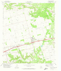 1971 Coahoma1974 Print · USGSThis West Texas region comes into focus in the early 1970s, showcasing the intersection of the petroleum industry and rural life. Researchers can trace the layout of Coahoma and find local landmarks like the Salem Ch, Sand Springs, and the Rodeo Ground.
 - 1971 Map of Big Spring North, 1974 Print
 1971 Big Spring North1974 Print · USGSHoward County's rail and ranching landscape comes alive in the late thirties, centered on the growing industrial hub of Big Spring. Genealogists can trace family footprints through rural districts like Luther and Sand Springs, or locate old landmarks like Bethel Ch and the Richland Sch.
End of results
Showing maps 1-2 of 2
Top cities near Coahoma
Frequently asked questions
- What are the different types of historical maps available for Coahoma?
- What is the oldest map of Coahoma?
- Where can I purchase historical maps of Coahoma for my home or office?
- Where can I download high-res historical maps of Coahoma?
- Are there historical topographic maps available for Coahoma?
- Is there historical aerial imagery available for Coahoma?
- Where are historical maps of Coahoma sourced from?