1900s (20th Century) Maps of Acala, Texas
Explore 5 historic maps of Acala from the 1900s (20th Century). These maps offer a rare glimpse into what life looked like during the 1900s — showing old roads, neighborhoods, homes, and landmarks that have changed or disappeared over time.
Whether you're researching your family's past, planning a metal detecting trip, or studying how Acala's landscape evolved across the 1900s, these high-resolution maps are a powerful tool for exploring the history of this region.
- Focus on a specific era: All maps on this page are from the 1900s, giving you a focused view of this time period.
- See what’s changed: Compare century-old streets, trails, and buildings to today's modern landscape using overlays and satellite layers.
- Research with precision: Use these maps for genealogy, historical research, land use analysis, or educational projects.
- View, download, or print: Maps are fully viewable online in high resolution, and can be downloaded or printed for your own records.
Start exploring Acala's history through authentic maps from the 1900s. This is your window into the past.
Acala, TX maps
(5)- 1943 Map of Fort Hancock
 1943 Fort Hancock1943 Print · USGSThe Rio Grande borderlands of West Texas during the early 1940s reveal a landscape of desert ranching and intensive river-fed irrigation. Genealogists and historians can trace rail-side settlements like Acala and Fort Hancock alongside the intricate Young Drain and McNary Main Canal systems.2 unique versions available
 - 1954 Map of Van Horn, 1964 Print
 1954 Van Horn1964 Print · USGSThe Trans-Pecos region of West Texas comes into focus in the mid-1950s as a vital corridor of rail and desert commerce. Researchers can trace the path of the Texas and Pacific through Van Horn or locate remote rail sidings like Borracho and Laska Siding.2 unique versions available
 - 1958 Map of Van Horn
 1958 Van Horn1958 Print · USGSWest Texas ranching and rail history come alive in this 1950s survey of the Trans-Pecos desert during the era of major steam-to-diesel transition. Genealogists and historians can trace family-named outposts like Mayfield Ranch or locate the ruins of Presidio Viejo along the Rio Grande.
 - 1972 Map of Acala, 1974 Print
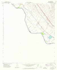 1972 Acala1974 Print · USGSThe Texas-Mexico borderlands come into focus in the 1970s, showcasing a desert landscape transformed by the Hudspeth Main Canal. Researchers can trace the intricate irrigation network surrounding Acala and the rail corridors of the Southern Pacific.
 - 1985 Map of Sierra Blanca
 1985 Sierra Blanca1985 Print · USGSThe Trans-Pecos desert during the mid-eighties shows a landscape of mountain ranges and critical international border crossings. Trace the old river settlements of Fort Hancock and Mc Nary, find the historic Fort Quitman (Site), or follow the legacy of the Southern Pacific railroad.2 unique versions available
End of results
Showing maps 1-5 of 5
Top cities near Acala
Frequently asked questions
- What are the different types of historical maps available for Acala?
- What is the oldest map of Acala?
- Where can I purchase historical maps of Acala for my home or office?
- Where can I download high-res historical maps of Acala?
- Are there historical topographic maps available for Acala?
- Is there historical aerial imagery available for Acala?
- Where are historical maps of Acala sourced from?