
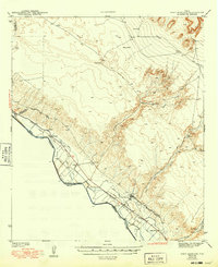
1943 Map of Fort Hancock
USGS Topo · Published 1943About this map
The Rio Grande defines the international boundary between the United States and Mexico in this arid West Texas landscape, where early 1940s agricultural development clings to the river's fertile floodplain. An intricate network of irrigation infrastructure, including the Upper Main Canal, Cooke Main Canal, and McNary Main Canal, supported the region's farms near Fort Hancock and Acala. These settlements are closely linked to the transport corridor formed by the Texas and Pacific and Southern Pacific railroads, which parallel the river and serve local stops like Acala Sta.
Find a feature on this map
33 named features on this map. Tap any name to fly to it.
Don’t see what you’re looking for? This feature index may not catch every label — zoom into the map to look around manually.
Map Details
Editions of this 1943 Fort Hancock Map
2 editions found
Other maps of this area

1894 · Fort Hancock
USGS Topo · 1:125,000

1896 · El Paso
USGS Topo · 1:125,000

1896 · Rio Grande
USGS Topo · 1:125,000

1903 · Cerro Alto
USGS Topo · 1:125,000

1908 · El Paso
USGS Topo · 1:125,000

1941 · Clint
USGS Topo · 1:62,500

1941 · Tornillo
USGS Topo · 1:62,500

1942 · Borrego
USGS Topo · 1:62,500

1943 · Fort Quitman
USGS Topo · 1:62,500

1943 · Tepee Butte
USGS Topo · 1:62,500