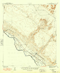
1943 Map of Fort Hancock
USGS Topo · Published 1949About this map
The Rio Grande valley in Hudspeth County serves as the focal point for this wartime survey, illustrating the complex irrigation and transportation network required to sustain agriculture in the West Texas desert. At the center of this landscape is Fort Hancock, situated near the confluence of several major drainage systems including Arroyo Alamo and Arroyo Rice. The map highlights a sophisticated hydraulic system featuring the Upper Main Canal, Cooke Canal, and several lateral drains that delineate the productive fields from the arid Rimrock terrain to the northeast.
Find a feature on this map
35 named features on this map. Tap any name to fly to it.
Don’t see what you’re looking for? This feature index may not catch every label — zoom into the map to look around manually.
Map Details
Editions of this 1943 Fort Hancock Map
2 editions found

Other maps of this area

1894 · Fort Hancock
USGS Topo · 1:125,000

1896 · El Paso
USGS Topo · 1:125,000

1896 · Rio Grande
USGS Topo · 1:125,000

1903 · Cerro Alto
USGS Topo · 1:125,000

1908 · El Paso
USGS Topo · 1:125,000

1941 · Clint
USGS Topo · 1:62,500

1941 · Tornillo
USGS Topo · 1:62,500

1942 · Borrego
USGS Topo · 1:62,500

1943 · Fort Quitman
USGS Topo · 1:62,500

1943 · Tepee Butte
USGS Topo · 1:62,500