
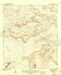
1943 Map of Tepee Butte
USGS Topo · Published 1943About this map
High desert rangeland in Hudspeth County is defined by a critical network of water infrastructure and isolated livestock operations as documented in the early 1940s. The landscape is dotted with named catchments like Santiago Tank, Alabama Tank, and Mohawk Tank, which supported the region's sparse ranching outposts including the Lee Moore Ranch and Molesworth Ranch. The terrain is punctuated by distinctive landforms such as Tepee Butte and Granite Mtn, while deep incisions like Alamo Canyon reveal the erosive forces of seasonal runoff. This survey, conducted by H. S. Milsted and other topographers for the War Department, highlights a dependence on well-watered draws like South Well Draw and the essential Hobo Well, illustrating the logistical challenges of life and industry in the Trans-Pecos before modern modernization.
Find a feature on this map
30 named features on this map. Tap any name to fly to it.
Don’t see what you’re looking for? This feature index may not catch every label — zoom into the map to look around manually.
Map Details
Editions of this 1943 Tepee Butte Map
2 editions found
Other maps of this area

1894 · Fort Hancock
USGS Topo · 1:125,000

1895 · Sierra Blanca
USGS Topo · 1:125,000

1903 · Cerro Alto
USGS Topo · 1:125,000

1941 · Heuco Mountains
USGS Topo · 1:62,500

1942 · Borrego
USGS Topo · 1:62,500

1943 · San Antonio Mtn
USGS Topo · 1:62,500

1943 · Heuco Mountains
USGS Topo · 1:62,500

1943 · Finlay Mountains
USGS Topo · 1:62,500

1943 · Fort Hancock
USGS Topo · 1:62,500

1948 · Triple Hill
USGS Topo · 1:62,500