1980s Maps of Dell City, Texas
Explore 2 historic maps of Dell City from the 1980s. These maps offer a rare glimpse into what life looked like during the 1980s — showing old roads, neighborhoods, homes, and landmarks that have changed or disappeared over time.
Whether you're researching your family's past, planning a metal detecting trip, or studying how Dell City's landscape evolved across the 1980s, these high-resolution maps are a powerful tool for exploring the history of this region.
- Focus on a specific era: All maps on this page are from the 1980s, giving you a focused view of this time period.
- See what’s changed: Compare century-old streets, trails, and buildings to today's modern landscape using overlays and satellite layers.
- Research with precision: Use these maps for genealogy, historical research, land use analysis, or educational projects.
- View, download, or print: Maps are fully viewable online in high resolution, and can be downloaded or printed for your own records.
Start exploring Dell City's history through authentic maps from the 1980s. This is your window into the past.
Dell City, TX maps
(2)- 1984 Map of Dell City, 1985 Print
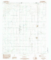 1984 Dell City1985 Print · USGSDell City and the northern reaches of Hudspeth County appear here in the early 1980s as a thriving desert agricultural hub. Researchers can trace the layout of the town's community spaces like the Rodeo Ground and Athletic Fields, or locate outlying landmarks such as Round Mountain and the Airport.
 - 1985 Map of Dell City
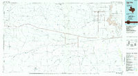 1985 Dell City1985 Print · USGSThe northern Chihuahuan Desert in the mid-1980s reveals a landscape of isolated farming hubs and vast salt basins. Genealogists and researchers can trace the roads and water tanks around Dell City, the remote outpost at Salt Flat, and the rugged slopes of the Sierra Diablo.2 unique versions available
End of results
Showing maps 1-2 of 2
Frequently asked questions
- What are the different types of historical maps available for Dell City?
- What is the oldest map of Dell City?
- Where can I purchase historical maps of Dell City for my home or office?
- Where can I download high-res historical maps of Dell City?
- Are there historical topographic maps available for Dell City?
- Is there historical aerial imagery available for Dell City?
- Where are historical maps of Dell City sourced from?