Old Maps of Esperanza, Texas for Academic Research
Study the evolution of Esperanza with 7 high-resolution historic maps. Whether you're teaching, researching, or modeling changes in land use, these maps provide essential visual documentation of urban, environmental, and geographic change.
- Analyze long-term change: Track patterns in development, transportation, and natural features.
- Ideal for environmental or urban studies: Support academic projects with primary historical map data.
- Use in the classroom or lab: Educators and researchers rely on these maps to bring historical context to life.
These maps are a powerful tool for teaching, research, and visualizing how Esperanza has changed over the decades.
Esperanza, TX maps
(7)- 1894 Map of Fort Hancock
 1894 Fort Hancock1894 Print · USGSWest Texas borderlands in the 1890s centered on the strategic military and rail corridor along the Rio Grande. Trace the early footprint of Fort Hancock Post and vanished outposts like Fort Quitman (Ab'd.) and Camp Rice (Ab'd.).4 unique versions available
 - 1943 Map of Fort Quitman
 1943 Fort Quitman1943 Print · USGSThe Texas-Mexico borderlands along the Rio Grande are captured here in the early 1940s, showing a landscape of irrigation canals and mountain mines. Genealogists and historians can locate remote landmarks like Fort Quitman, the Bonanza Mine, and family sites such as Neeley Ranch.
 - 1954 Map of Van Horn, 1964 Print
 1954 Van Horn1964 Print · USGSThe Trans-Pecos region of West Texas comes into focus in the mid-1950s as a vital corridor of rail and desert commerce. Researchers can trace the path of the Texas and Pacific through Van Horn or locate remote rail sidings like Borracho and Laska Siding.2 unique versions available
 - 1958 Map of Van Horn
 1958 Van Horn1958 Print · USGSWest Texas ranching and rail history come alive in this 1950s survey of the Trans-Pecos desert during the era of major steam-to-diesel transition. Genealogists and historians can trace family-named outposts like Mayfield Ranch or locate the ruins of Presidio Viejo along the Rio Grande.
 - 1972 Map of Esperanza, 1975 Print
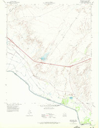 1972 Esperanza1975 Print · USGSThe West Texas borderlands in the early seventies reveal a desert landscape transformed by irrigation and rail. Genealogists and historians can trace the settlement of Esperanza, follow the Southern Pacific tracks, or locate old waterworks like Fort Quitman Lake.
 - 1985 Map of Sierra Blanca
 1985 Sierra Blanca1985 Print · USGSThe Trans-Pecos desert during the mid-eighties shows a landscape of mountain ranges and critical international border crossings. Trace the old river settlements of Fort Hancock and Mc Nary, find the historic Fort Quitman (Site), or follow the legacy of the Southern Pacific railroad.2 unique versions available
 - 2022 Map of Esperanza, 2022 Print
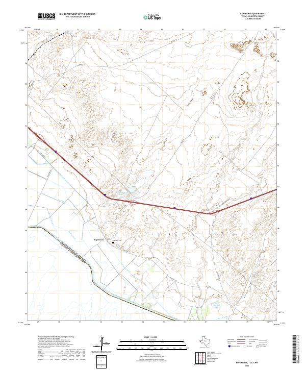 2022 Esperanza2022 Print · USGSAlong the international border in Hudspeth County, this modern survey details the vital irrigation and desert landmarks of the Rio Grande valley. Local researchers can trace family sites near Esperanza, locate the Esperanza Cem, and follow the paths of Arroyo Macho and the Dave Gill Canal.
End of results
Showing maps 1-7 of 7
Top cities near Esperanza
Frequently asked questions
- What are the different types of historical maps available for Esperanza?
- What is the oldest map of Esperanza?
- Where can I purchase historical maps of Esperanza for my home or office?
- Where can I download high-res historical maps of Esperanza?
- Are there historical topographic maps available for Esperanza?
- Is there historical aerial imagery available for Esperanza?
- Where are historical maps of Esperanza sourced from?