1900s (20th Century) Maps of Neylandville, Texas
Explore 9 historic maps of Neylandville from the 1900s (20th Century). These maps offer a rare glimpse into what life looked like during the 1900s — showing old roads, neighborhoods, homes, and landmarks that have changed or disappeared over time.
Whether you're researching your family's past, planning a metal detecting trip, or studying how Neylandville's landscape evolved across the 1900s, these high-resolution maps are a powerful tool for exploring the history of this region.
- Focus on a specific era: All maps on this page are from the 1900s, giving you a focused view of this time period.
- See what’s changed: Compare century-old streets, trails, and buildings to today's modern landscape using overlays and satellite layers.
- Research with precision: Use these maps for genealogy, historical research, land use analysis, or educational projects.
- View, download, or print: Maps are fully viewable online in high resolution, and can be downloaded or printed for your own records.
Start exploring Neylandville's history through authentic maps from the 1900s. This is your window into the past.
Neylandville, TX maps
(9)- 1953 Map of Texarkana, 1964 Print
 1953 Texarkana1964 Print · USGSThe Texas-Arkansas borderlands are captured here in the mid-fifties, during a decade of massive military and hydraulic engineering projects. Genealogists and researchers can locate family landmarks like Old Boston Cem, Siloam Ch, and the vast Red River Arsenal.4 unique versions available
 - 1954 Map of Sherman, 1964 Print
 1954 Sherman1964 Print · USGSThe Red River valley and North Texas plains are captured here in the mid-fifties, showing the region as new reservoirs like Lake Texoma and Lavon Reservoir reshaped the land. Genealogists can trace family roots through specific local landmarks like Courtney P O, Pilot Grove Sch, and New Hope Ch.2 unique versions available
 - 1956 Map of Texarkana
 1956 Texarkana1956 Print · USGSThe Ark-La-Tex borderlands come alive in the mid-fifties, showing the transition from a rail-dependent rural economy to a post-war industrial landscape. Researchers can trace the massive Red River Ordnance Depot and find towns like Talco, Bogata, and Naples.
 - 1958 Map of Sherman, 1959 Print
 1958 Sherman1959 Print · USGSNorth Texas and Southern Oklahoma were undergoing significant development in the late fifties as the Red River Valley transit networks matured. Researchers can trace historic family-named locations such as Saddler Bend, the grounds of Perrin AFB, and early shoreline developments at Lake Texoma.
 - 1963 Map of Greenville NE, 1964 Print
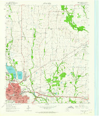 1963 Greenville NE1964 Print · USGSHunt County in the early sixties is captured here as a critical rail hub where three major lines meet. Researchers can trace family history through sites like Old Concord Ch, Hopkins No 1 Cem, and the community of Neylandville.3 unique versions available
 - 1964 Map of Commerce South, 1968 Print
 1964 Commerce South1968 Print · USGSThe hunt for family roots and rural Texas history in the mid-sixties leads through Commerce and the South Sulphur River valley. Trace the old rail lines and find landmarks like East Texas State College, the Rodeo Ground, and numerous family burial sites like Brigham Cem.
 - 1985 Map of McKinney
 1985 McKinney1985 Print · USGSNorth Texas in the mid-1980s was a landscape of rural communities connected by a complex web of railroads and creek systems. Researchers can trace family roots through settlements like Westminster, find local landmarks like Henslee Chapel, or map the industrial activity at various Gravel Pits.2 unique versions available
 - 1985 Map of Sulphur Springs
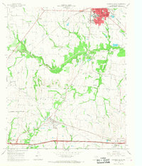
 1985 Sulphur Springs1985 Print · USGSNortheast Texas in the mid-eighties shows a landscape transitioning between its deep-rooted rail towns and a new era of reservoir development. Genealogists and historians can trace family locations near Shooks Chapel, the rural Farmers Academy, and the banks of the South Sulphur River.
 - 1991 Map of Sulphur Springs
 1991 Sulphur Springs1991 Print · USGSNortheast Texas in the early nineties shows a transition from rail-dependent agriculture to a landscape defined by massive reservoirs. Researchers can trace rural lineages through sites like Gafford Chapel and the Forest Academy Cem, or follow the path of the St Louis Southwestern RR.
End of results
Showing maps 1-9 of 9
Top cities near Neylandville
- Greenville historical maps
- Commerce historical maps
- Caddo Mills historical maps
- Leonard historical maps
- Wolfe City historical maps
- Celeste historical maps
See more
Frequently asked questions
- What are the different types of historical maps available for Neylandville?
- What is the oldest map of Neylandville?
- Where can I purchase historical maps of Neylandville for my home or office?
- Where can I download high-res historical maps of Neylandville?
- Are there historical topographic maps available for Neylandville?
- Is there historical aerial imagery available for Neylandville?
- Where are historical maps of Neylandville sourced from?