1960s Maps of Beaumont, Texas
Explore 6 historic maps of Beaumont from the 1960s. These maps offer a rare glimpse into what life looked like during the 1960s — showing old roads, neighborhoods, homes, and landmarks that have changed or disappeared over time.
Whether you're researching your family's past, planning a metal detecting trip, or studying how Beaumont's landscape evolved across the 1960s, these high-resolution maps are a powerful tool for exploring the history of this region.
- Focus on a specific era: All maps on this page are from the 1960s, giving you a focused view of this time period.
- See what’s changed: Compare century-old streets, trails, and buildings to today's modern landscape using overlays and satellite layers.
- Research with precision: Use these maps for genealogy, historical research, land use analysis, or educational projects.
- View, download, or print: Maps are fully viewable online in high resolution, and can be downloaded or printed for your own records.
Start exploring Beaumont's history through authentic maps from the 1960s. This is your window into the past.
Beaumont, TX maps
(6)- 1960 Map of Beaumont West, 1962 Print
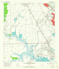
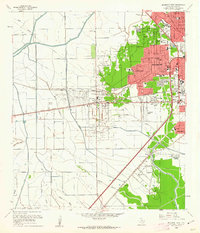 1960 Beaumont West1962 Print · USGSBeaumont expands westward toward the oil fields in the early sixties as new residential suburbs replace the coastal prairie. Trace local history through Amelia, the Hebert Cem, and numerous neighborhood landmarks like French High Sch.4 unique versions available
 - 1960 Map of Voth, 1962 Print
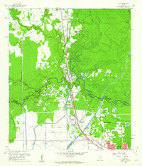 1960 Voth1962 Print · USGSThe Hardin and Jefferson county line comes alive in the early sixties as the suburbs of Beaumont meet the oil fields and bayous. Researchers can trace family roots through the Voth-Rosedale Sch, the Ariola Oil Field, and the Mt Sinai Ch.3 unique versions available
 - 1960 Map of Pine Forest, 1962 Print
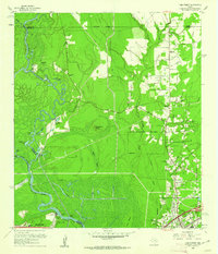 1960 Pine Forest1962 Print · USGSSoutheast Texas near the Neches River was undergoing significant industrial and suburban growth in the early sixties. Researchers can trace family history at Williamson Cem or locate early landmarks like Colliers Ferry (Site) and Vidor.3 unique versions available
 - 1960 Map of Beaumont East, 1962 Print
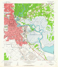 1960 Beaumont East1962 Print · USGSThe Beaumont area in the early sixties thrived as an industrial powerhouse defined by the petroleum industry and the winding Neches River. Researchers can trace the layout of the iconic Spindletop Oil Field, locate Hebert High Sch, and explore the rail networks of the Southern Pacific.6 unique versions available
 - 1962 Map of Fannett East, 1964 Print
 1962 Fannett East1964 Print · USGSJefferson County in the early sixties was a landscape where coastal bayous met a growing industrial infrastructure. Genealogists can locate family sites like Broussard Cem while tracing the rail-side growth of Fannett and Cheek near the Gulf Colorado and Santa Fe line.
 - 1962 Map of Port Acres, 1964 Print
 1962 Port Acres1964 Print · USGSJefferson County was an industrial powerhouse in the early sixties, where the legacy of the oil boom met postwar suburban growth. Genealogists and historians can trace neighborhood developments like Central Gardens alongside landmarks such as Stephen F Austin High Sch and the Spindletop Oil Field.4 unique versions available
End of results
Showing maps 1-6 of 6
Top cities near Beaumont
- Port Arthur historical maps
- Nederland historical maps
- Groves historical maps
- Port Neches historical maps
- Vidor historical maps
- Lumberton historical maps
See more
Top neighborhoods of Beaumont
- Amelia historical maps
- Rosedale historical maps
- Gladys historical maps
- Lucas historical maps
- Spindletop historical maps
- West Oakland historical maps
See more
Frequently asked questions
- What are the different types of historical maps available for Beaumont?
- What is the oldest map of Beaumont?
- Where can I purchase historical maps of Beaumont for my home or office?
- Where can I download high-res historical maps of Beaumont?
- Are there historical topographic maps available for Beaumont?
- Is there historical aerial imagery available for Beaumont?
- Where are historical maps of Beaumont sourced from?