Old Maps of Beaumont, Texas for Metal Detecting
Plan your next treasure hunt with 56 historic maps of Beaumont. Find old homesites, ghost towns, trails, and gathering spots that may be lost to time — perfect for identifying promising metal detecting locations.
- Locate forgotten sites: Uncover places like long-lost settlements, abandoned rail lines, or gathering spots.
- Plan better hunts: Use map overlays combined with LiDAR or satellite views to narrow in on historically rich areas.
- Made for detectorists: Thousands of hobbyists use these maps to discover relics, coins, and hidden history.
Use these historic maps to boost your research and find new opportunities beneath the surface of Beaumont.
Beaumont, TX maps
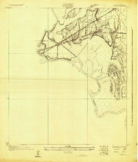
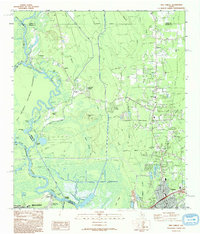
(56)- 1926 Map of Lakeview
 1926 Lakeview1926 Print · USGSThe Neches River lowlands are captured here in the mid-1920s, showing a landscape defined by marshy sloughs and emerging industry. Genealogists and historians can locate family landmarks like the Williamson Church or trace old routes to Colliers Ferry.
 - 1926 Map of Vidor
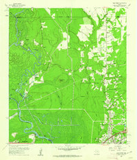
 1926 Vidor1926 Print · USGSThe Neches River basin in the mid-1920s shows a landscape of winding waterways and emerging rail corridors. Researchers can trace the early footprint of Vidor and find rural landmarks like the Magnolia Grove School alongside the Kansas City Southern line.
 - 1932 Map of Beaumont
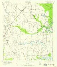
 1932 Beaumont1932 Print · USGSThe Neches River lowlands and the growing settlement of Vidor are captured here during the early thirties. Genealogists can locate family landmarks like Magnolia Grove Sch, Williamson Ch, and the river crossing at Colliers Ferry.2 unique versions available
 - 1943 Map of Fannett East, 1959 Print
 1943 Fannett East1959 Print · USGSJefferson County is mapped during the early 1940s, showing a coastal landscape of bayous and railroads at the height of its mid-century industrial growth. Researchers can trace family history at Broussard Cem or follow the Gulf Colorado and Santa Fe line through Cheek.2 unique versions available
 - 1943 Map of Beaumont East, 1960 Print
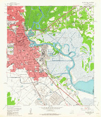
 1943 Beaumont East1960 Print · USGSIn the midst of the Second World War, the Texas Gulf Coast's industrial heart thrived along the Neches River and its vital shipping channels. Genealogists and historians can trace the early layout of Lamar College, the famous Spindletop Oil Field, and family plots in Anthony Cem.
 - 1945 Map of Fannett East
 1945 Fannett East1945 Print · USGSJefferson County coastal prairies and bayous are captured here during the mid-1940s. Researchers can trace local lineage through Broussard Cem, visit the old Fannett School, and map the water-driven economy of Lovell Lake and Bayou Din.
 - 1950 Map of Houston, 1953 Print
 1950 Houston1953 Print · USGSCoastal Texas in the early fifties reveals a landscape of massive civil engineering and industrial transit. Genealogists and researchers can trace the growth of the Houston suburbs and the maritime infrastructure of Galveston Bay, including the Gulf Freeway and the Texas City Dike.
 - 1954 Map of Beaumont, 1964 Print
 1954 Beaumont1964 Print · USGSSoutheast Texas in the mid-fifties reveals a landscape of massive national forests, emerging reservoirs, and a booming oil economy. Genealogists and researchers can trace rural settlements like Dallardsville and Village Mills or locate early drilling sites at Sour Lake Oil Field.3 unique versions available
 - 1956 Map of Houston, 1963 Print
 1956 Houston1963 Print · USGSSoutheast Texas in the mid-fifties is captured here as a powerhouse of oil and maritime trade. Genealogists and historians can trace the foundations of Houston and its ports, alongside landmarks like the Rice Institute and the Spindletop Oil Field.2 unique versions available
 - 1957 Map of Beaumont
 1957 Beaumont1957 Print · USGSSoutheast Texas in the mid-fifties is defined by the timber-rich lands between the Trinity River and Beaumont. Trace the history of the Alabama and Coushatti Indian Reservation or locate early campus sites like Prairie View College.
 - 1960 Map of Beaumont West, 1962 Print
 1960 Beaumont West1962 Print · USGSBeaumont expands westward toward the oil fields in the early sixties as new residential suburbs replace the coastal prairie. Trace local history through Amelia, the Hebert Cem, and numerous neighborhood landmarks like French High Sch.4 unique versions available
 - 1960 Map of Voth, 1962 Print
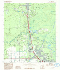
 1960 Voth1962 Print · USGSThe Hardin and Jefferson county line comes alive in the early sixties as the suburbs of Beaumont meet the oil fields and bayous. Researchers can trace family roots through the Voth-Rosedale Sch, the Ariola Oil Field, and the Mt Sinai Ch.3 unique versions available
 - 1960 Map of Pine Forest, 1962 Print
 1960 Pine Forest1962 Print · USGSSoutheast Texas near the Neches River was undergoing significant industrial and suburban growth in the early sixties. Researchers can trace family history at Williamson Cem or locate early landmarks like Colliers Ferry (Site) and Vidor.3 unique versions available
 - 1960 Map of Beaumont East, 1962 Print
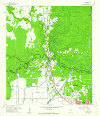
 1960 Beaumont East1962 Print · USGSThe Beaumont area in the early sixties thrived as an industrial powerhouse defined by the petroleum industry and the winding Neches River. Researchers can trace the layout of the iconic Spindletop Oil Field, locate Hebert High Sch, and explore the rail networks of the Southern Pacific.6 unique versions available
 - 1962 Map of Fannett East, 1964 Print
 1962 Fannett East1964 Print · USGSJefferson County in the early sixties was a landscape where coastal bayous met a growing industrial infrastructure. Genealogists can locate family sites like Broussard Cem while tracing the rail-side growth of Fannett and Cheek near the Gulf Colorado and Santa Fe line.
 - 1962 Map of Port Acres, 1964 Print
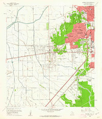
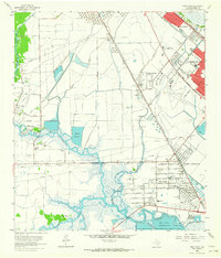 1962 Port Acres1964 Print · USGSJefferson County was an industrial powerhouse in the early sixties, where the legacy of the oil boom met postwar suburban growth. Genealogists and historians can trace neighborhood developments like Central Gardens alongside landmarks such as Stephen F Austin High Sch and the Spindletop Oil Field.4 unique versions available
 - 1975 Map of Houston, 1977 Print
 1975 Houston1977 Print · USGSThe Texas Gulf Coast in the mid-seventies shows a sprawling Houston metropolis linked to the sea by the massive Houston Ship Channel. Researchers can trace the mid-century industrial landscape from the Astrodome to the Lyndon B. Johnson Space Center.2 unique versions available
 - 1983 Map of Anahuac
 1983 Anahuac1983 Print · USGSThe Upper Texas Coast and its energy-driven landscape are detailed here in the early eighties. Genealogists and historians can trace coastal settlements like Anahuac and Winnie alongside the storied Spindletop Oil Field and the Anahuac National Wildlife Refuge.2 unique versions available
 - 1984 Map of Beaumont
 1984 Beaumont1984 Print · USGSSoutheast Texas in the late seventies and early eighties shows a landscape of expanding reservoirs and deep timber industry. Researchers can trace the development of the Sam Houston National Forest or locate regional landmarks like Grabbs Prairie and the Wynne State Prison Farm.3 unique versions available
 - 1986 Map of Beaumont
 1986 Beaumont1986 Print · USGSThe East Texas piney woods and coastal prairies are captured here in the mid-eighties, a period of established energy production and conservation. Researchers can trace the industrial footprint of the Oil and Gas Field near Daisetta and Batson, or locate family sites at Graveyard Hill Cem.
 - 1993 Map of Voth
 1993 Voth1993 Print · USGSCoastal Texas wetlands and suburban growth meet in the early nineties as the Beaumont area expands northward. Researchers can trace historical footprints through the Arriola Oil Field, the Rosedale Sch, and the winding Neches River.
 - 1993 Map of Pine Forest
 1993 Pine Forest1993 Print · USGSThe Neches River bottomlands and the growth of Vidor define this Southeast Texas landscape in the early nineties. Researchers can trace the layout of Restlawn Memorial Park (Cem), old crossings like Lawson Crossing, and the wild edges of the Big Thicket National Preserve.
 - 1993 Map of Port Acres, 1994 Print
 1993 Port Acres1994 Print · USGSJefferson County in the early nineties shows the heavy industrial and residential footprint of the Texas Gulf Coast. Researchers can trace the legacy of the oil boom through Spindletop and Beaumont Field or find family history at Memory Gardens.
 - 1994 Map of Beaumont East
 1994 Beaumont East1994 Print · USGSMid-nineties Beaumont and the Neches River are defined by the legacy of the petroleum industry and rapid urban expansion. Researchers can trace historic neighborhoods and industrial sites from the Spindletop Oil Field to Lamar University and the Magnolia Cemetery.
 - 1994 Map of Fannett East
 1994 Fannett East1994 Print · USGSJefferson County's coastal prairie is shown here in the 1990s, where industrial pipelines and oil wells meet traditional ranching and bayou life. Researchers can locate family landmarks like Broussard Cem or trace the early development of Fannett and Cheek.
Showing maps 1-25 of 56
Top cities near Beaumont
- Port Arthur historical maps
- Nederland historical maps
- Groves historical maps
- Port Neches historical maps
- Vidor historical maps
- Lumberton historical maps
See more
Top neighborhoods of Beaumont
- Amelia historical maps
- Rosedale historical maps
- Gladys historical maps
- Lucas historical maps
- Spindletop historical maps
- West Oakland historical maps
See more
Frequently asked questions
- What are the different types of historical maps available for Beaumont?
- What is the oldest map of Beaumont?
- Where can I purchase historical maps of Beaumont for my home or office?
- Where can I download high-res historical maps of Beaumont?
- Are there historical topographic maps available for Beaumont?
- Is there historical aerial imagery available for Beaumont?
- Where are historical maps of Beaumont sourced from?