1900s (20th Century) Maps of Old Town, Beaumont
Explore 11 historic maps of Old Town from the 1900s (20th Century). These maps offer a rare glimpse into what life looked like during the 1900s — showing old roads, neighborhoods, homes, and landmarks that have changed or disappeared over time.
Whether you're researching your family's past, planning a metal detecting trip, or studying how Old Town's landscape evolved across the 1900s, these high-resolution maps are a powerful tool for exploring the history of this region.
- Focus on a specific era: All maps on this page are from the 1900s, giving you a focused view of this time period.
- See what’s changed: Compare century-old streets, trails, and buildings to today's modern landscape using overlays and satellite layers.
- Research with precision: Use these maps for genealogy, historical research, land use analysis, or educational projects.
- View, download, or print: Maps are fully viewable online in high resolution, and can be downloaded or printed for your own records.
Start exploring Old Town's history through authentic maps from the 1900s. This is your window into the past.
Old Town, Beaumont maps
(11)- 1926 Map of Vidor
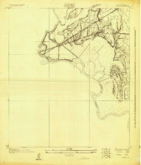 1926 Vidor1926 Print · USGSThe Neches River basin in the mid-1920s shows a landscape of winding waterways and emerging rail corridors. Researchers can trace the early footprint of Vidor and find rural landmarks like the Magnolia Grove School alongside the Kansas City Southern line.
 - 1932 Map of Beaumont
 1932 Beaumont1932 Print · USGSThe Neches River lowlands and the growing settlement of Vidor are captured here during the early thirties. Genealogists can locate family landmarks like Magnolia Grove Sch, Williamson Ch, and the river crossing at Colliers Ferry.2 unique versions available
 - 1943 Map of Beaumont East, 1960 Print
 1943 Beaumont East1960 Print · USGSIn the midst of the Second World War, the Texas Gulf Coast's industrial heart thrived along the Neches River and its vital shipping channels. Genealogists and historians can trace the early layout of Lamar College, the famous Spindletop Oil Field, and family plots in Anthony Cem.
 - 1954 Map of Beaumont, 1964 Print
 1954 Beaumont1964 Print · USGSSoutheast Texas in the mid-fifties reveals a landscape of massive national forests, emerging reservoirs, and a booming oil economy. Genealogists and researchers can trace rural settlements like Dallardsville and Village Mills or locate early drilling sites at Sour Lake Oil Field.3 unique versions available
 - 1957 Map of Beaumont
 1957 Beaumont1957 Print · USGSSoutheast Texas in the mid-fifties is defined by the timber-rich lands between the Trinity River and Beaumont. Trace the history of the Alabama and Coushatti Indian Reservation or locate early campus sites like Prairie View College.
 - 1960 Map of Beaumont West, 1962 Print
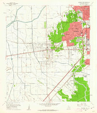 1960 Beaumont West1962 Print · USGSBeaumont expands westward toward the oil fields in the early sixties as new residential suburbs replace the coastal prairie. Trace local history through Amelia, the Hebert Cem, and numerous neighborhood landmarks like French High Sch.4 unique versions available
 - 1960 Map of Beaumont East, 1962 Print
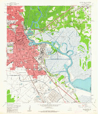 1960 Beaumont East1962 Print · USGSThe Beaumont area in the early sixties thrived as an industrial powerhouse defined by the petroleum industry and the winding Neches River. Researchers can trace the layout of the iconic Spindletop Oil Field, locate Hebert High Sch, and explore the rail networks of the Southern Pacific.6 unique versions available
 - 1984 Map of Beaumont
 1984 Beaumont1984 Print · USGSSoutheast Texas in the late seventies and early eighties shows a landscape of expanding reservoirs and deep timber industry. Researchers can trace the development of the Sam Houston National Forest or locate regional landmarks like Grabbs Prairie and the Wynne State Prison Farm.3 unique versions available
 - 1986 Map of Beaumont
 1986 Beaumont1986 Print · USGSThe East Texas piney woods and coastal prairies are captured here in the mid-eighties, a period of established energy production and conservation. Researchers can trace the industrial footprint of the Oil and Gas Field near Daisetta and Batson, or locate family sites at Graveyard Hill Cem.
 - 1994 Map of Beaumont East
 1994 Beaumont East1994 Print · USGSMid-nineties Beaumont and the Neches River are defined by the legacy of the petroleum industry and rapid urban expansion. Researchers can trace historic neighborhoods and industrial sites from the Spindletop Oil Field to Lamar University and the Magnolia Cemetery.
 - 1994 Map of Beaumont West
 1994 Beaumont West1994 Print · USGSThe western suburbs of Beaumont show a complex mix of mid-century growth and industrial infrastructure during the 1990s. Researchers can trace local landmarks like Amelia, the Beaumont Municipal Airport, and the southern routes of the Southern Pacific railroad.
End of results
Showing maps 1-11 of 11
Frequently asked questions
- What are the different types of historical maps available for Old Town?
- What is the oldest map of Old Town?
- Where can I purchase historical maps of Old Town for my home or office?
- Where can I download high-res historical maps of Old Town?
- Are there historical topographic maps available for Old Town?
- Is there historical aerial imagery available for Old Town?
- Where are historical maps of Old Town sourced from?