1960s Maps of Port Arthur, Texas
Explore 2 historic maps of Port Arthur from the 1960s. These maps offer a rare glimpse into what life looked like during the 1960s — showing old roads, neighborhoods, homes, and landmarks that have changed or disappeared over time.
Whether you're researching your family's past, planning a metal detecting trip, or studying how Port Arthur's landscape evolved across the 1960s, these high-resolution maps are a powerful tool for exploring the history of this region.
- Focus on a specific era: All maps on this page are from the 1960s, giving you a focused view of this time period.
- See what’s changed: Compare century-old streets, trails, and buildings to today's modern landscape using overlays and satellite layers.
- Research with precision: Use these maps for genealogy, historical research, land use analysis, or educational projects.
- View, download, or print: Maps are fully viewable online in high resolution, and can be downloaded or printed for your own records.
Start exploring Port Arthur's history through authentic maps from the 1960s. This is your window into the past.
Port Arthur, TX maps
(2)- 1962 Map of Port Acres, 1964 Print
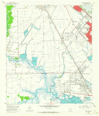 1962 Port Acres1964 Print · USGSJefferson County was an industrial powerhouse in the early sixties, where the legacy of the oil boom met postwar suburban growth. Genealogists and historians can trace neighborhood developments like Central Gardens alongside landmarks such as Stephen F Austin High Sch and the Spindletop Oil Field.4 unique versions available
 - 1962 Map of Big Hill Bayou, 1964 Print
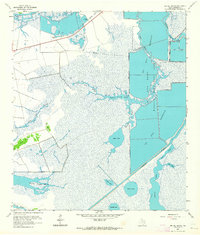 1962 Big Hill Bayou1964 Print · USGSJefferson County’s coastal marshes were undergoing significant hydrological changes in the early sixties as industrial infrastructure expanded. Researchers can trace the original wetlands surrounding Gum Island and the path of the Intracoastal Waterway near Shell Lake.3 unique versions available
End of results
Showing maps 1-2 of 2
Top cities near Port Arthur
- Beaumont historical maps
- Orange historical maps
- Nederland historical maps
- Groves historical maps
- Port Neches historical maps
- Bridge City historical maps
See more
Top neighborhoods of Port Arthur
- Sabine historical maps
- Griffing Park historical maps
- Sabine Pass historical maps
- Lakeview historical maps
- Pear Ridge historical maps
- Port Acres historical maps
Frequently asked questions
- What are the different types of historical maps available for Port Arthur?
- What is the oldest map of Port Arthur?
- Where can I purchase historical maps of Port Arthur for my home or office?
- Where can I download high-res historical maps of Port Arthur?
- Are there historical topographic maps available for Port Arthur?
- Is there historical aerial imagery available for Port Arthur?
- Where are historical maps of Port Arthur sourced from?