1900s (20th Century) Maps of Premont, Texas
Explore 5 historic maps of Premont from the 1900s (20th Century). These maps offer a rare glimpse into what life looked like during the 1900s — showing old roads, neighborhoods, homes, and landmarks that have changed or disappeared over time.
Whether you're researching your family's past, planning a metal detecting trip, or studying how Premont's landscape evolved across the 1900s, these high-resolution maps are a powerful tool for exploring the history of this region.
- Focus on a specific era: All maps on this page are from the 1900s, giving you a focused view of this time period.
- See what’s changed: Compare century-old streets, trails, and buildings to today's modern landscape using overlays and satellite layers.
- Research with precision: Use these maps for genealogy, historical research, land use analysis, or educational projects.
- View, download, or print: Maps are fully viewable online in high resolution, and can be downloaded or printed for your own records.
Start exploring Premont's history through authentic maps from the 1900s. This is your window into the past.
Premont, TX maps
(5)- 1921 Map of Falfurrias
 1921 Falfurrias1921 Print · USGSBrooks and Jim Wells counties were defined by a sprawling ranching and citrus economy in the years following the Great War. Genealogists can trace family holdings and early infrastructure like Coyote Mills, the Concepcion Ruins, and the Seymour Citrus Farm.
 - 1956 Map of Laredo, 1960 Print
 1956 Laredo1960 Print · USGSSouth Texas in the mid-fifties reveals a landscape shaped by border commerce, military aviation, and a booming oil industry. Trace the historic Texas and Mexican RR line through Hebbronville or locate the sprawling Mirando City Oil Field and Laredo AFB.3 unique versions available
 - 1963 Map of Premont West, 1964 Print
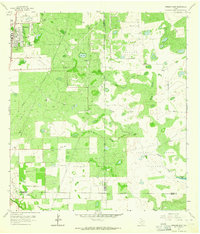
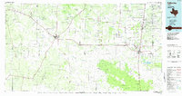
 1963 Premont West1964 Print · USGSJim Wells County in the early 1960s was a hub of energy production and ranching at the meeting point of three counties. Genealogists and historians can trace the Southern Pacific rail corridor through Premont and La Gloria, and locate rural landmarks like the La Gloria Sch and the Drive-in Theater.
 - 1963 Map of Premont East, 1964 Print
 1963 Premont East1964 Print · USGSThe South Texas brush country at the height of the mid-century energy boom is captured here in detail. Researchers can trace the development of the Tijerina Canales Blucher Oil Field or locate family sites near Palobla and Premont.2 unique versions available
 - 1985 Map of Falfurrias
 1985 Falfurrias1985 Print · USGSThe ranchlands of South Texas were an active hub for rail and petroleum at the height of the mid-eighties. Researchers can trace the path of the Texas Mexican RR through Hebbronville or locate the Thanksgiving Oil Field and Sejita crossroads.2 unique versions available
End of results
Showing maps 1-5 of 5
Top cities near Premont
Frequently asked questions
- What are the different types of historical maps available for Premont?
- What is the oldest map of Premont?
- Where can I purchase historical maps of Premont for my home or office?
- Where can I download high-res historical maps of Premont?
- Are there historical topographic maps available for Premont?
- Is there historical aerial imagery available for Premont?
- Where are historical maps of Premont sourced from?