1960s Maps of Alvarado, Texas
Explore 4 historic maps of Alvarado from the 1960s. These maps offer a rare glimpse into what life looked like during the 1960s — showing old roads, neighborhoods, homes, and landmarks that have changed or disappeared over time.
Whether you're researching your family's past, planning a metal detecting trip, or studying how Alvarado's landscape evolved across the 1960s, these high-resolution maps are a powerful tool for exploring the history of this region.
- Focus on a specific era: All maps on this page are from the 1960s, giving you a focused view of this time period.
- See what’s changed: Compare century-old streets, trails, and buildings to today's modern landscape using overlays and satellite layers.
- Research with precision: Use these maps for genealogy, historical research, land use analysis, or educational projects.
- View, download, or print: Maps are fully viewable online in high resolution, and can be downloaded or printed for your own records.
Start exploring Alvarado's history through authentic maps from the 1960s. This is your window into the past.
Alvarado, TX maps
(4)- 1960 Map of Keene, 1963 Print
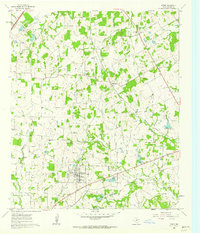 1960 Keene1963 Print · USGSJohnson County is shown here during a period of steady growth centered on the town of Keene and its local college. Genealogists and historians can trace the foundations of the community through rural landmarks like Lane Prairie Ch, Hopewell Cem, and the path of the Missouri Kansas and Texas railroad.3 unique versions available
 - 1960 Map of Cleburne East, 1963 Print
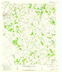 1960 Cleburne East1963 Print · USGSThe eastern outskirts of Cleburne and the nearby rural farming communities appear here in the early 1960s. Genealogists and local historians can trace rural congregations and family burial sites like Watts Chapel, Morrow Cem, and the Liberty Chapel Sch.4 unique versions available
 - 1961 Map of Alvarado, 1963 Print
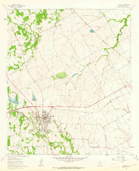 1961 Alvarado1963 Print · USGSAlvarado and the surrounding Johnson County prairies appear at the height of the railroad era in the early 1960s. Genealogists can trace family footprints at Glenwood Cemetery or the Duke Cem, and locate landmarks like the Geo Washington Carver school.3 unique versions available
 - 1961 Map of Grandview, 1963 Print
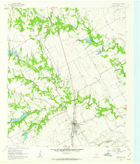 1961 Grandview1963 Print · USGSGrandview and the surrounding Johnson County prairies are captured in the early sixties as the railroad still drove the local economy. Genealogists and local historians can trace family plots at Old Hill Cem and Boatright Cem or locate the site of Antioch.2 unique versions available
End of results
Showing maps 1-4 of 4
Top cities near Alvarado
- Dallas historical maps
- Fort Worth historical maps
- Arlington historical maps
- Grand Prairie historical maps
- Mansfield historical maps
- Cedar Hill historical maps
See more
Frequently asked questions
- What are the different types of historical maps available for Alvarado?
- What is the oldest map of Alvarado?
- Where can I purchase historical maps of Alvarado for my home or office?
- Where can I download high-res historical maps of Alvarado?
- Are there historical topographic maps available for Alvarado?
- Is there historical aerial imagery available for Alvarado?
- Where are historical maps of Alvarado sourced from?