1960s Maps of Scurry, Texas
Explore 4 historic maps of Scurry from the 1960s. These maps offer a rare glimpse into what life looked like during the 1960s — showing old roads, neighborhoods, homes, and landmarks that have changed or disappeared over time.
Whether you're researching your family's past, planning a metal detecting trip, or studying how Scurry's landscape evolved across the 1960s, these high-resolution maps are a powerful tool for exploring the history of this region.
- Focus on a specific era: All maps on this page are from the 1960s, giving you a focused view of this time period.
- See what’s changed: Compare century-old streets, trails, and buildings to today's modern landscape using overlays and satellite layers.
- Research with precision: Use these maps for genealogy, historical research, land use analysis, or educational projects.
- View, download, or print: Maps are fully viewable online in high resolution, and can be downloaded or printed for your own records.
Start exploring Scurry's history through authentic maps from the 1960s. This is your window into the past.
Scurry, TX maps
(4)- 1960 Map of Grays Prairie, 1962 Print
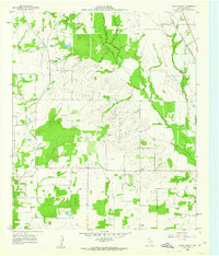 1960 Grays Prairie1962 Print · USGSKaufman County's rural landscape is preserved here during the early sixties, showing a world of small farm communities and creek-bottom timber. Researchers can locate family landmarks like Pyles Prairie Cem, the village of Lively, and the Coney Shilo Ch.3 unique versions available
 - 1962 Map of Scurry, 1966 Print
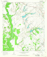 1962 Scurry1966 Print · USGSKaufman County agricultural land and flood control projects are documented here in the early sixties. Researchers can trace rural life through the Mt Olive Cem, the Pleasant Grove Ch, and the old Southern Pacific rail line.2 unique versions available
 - 1963 Map of Rosser
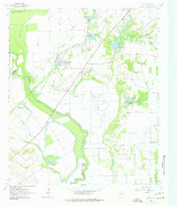 1963 Rosser1963 Print · USGSThe Trinity River bottomlands near the Kaufman and Ellis County line come to life in the early 1960s. Genealogists and local historians can trace family connections at Rosser Cemetery and Cottonwood Church or locate the site of the Scurry-Rosser School.2 unique versions available
 - 1963 Map of Kaufman, 1965 Print
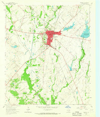 1963 Kaufman1965 Print · USGSKaufman and its surrounding agricultural outskirts are captured in the early sixties as the town served as a bustling rail and civic center. Genealogists and researchers can trace the Southern Pacific line, locate family names near Jiba, and find local landmarks like St Ann Ch or the County Farm.
End of results
Showing maps 1-4 of 4
Top cities near Scurry
- Dallas historical maps
- Mesquite historical maps
- Balch Springs historical maps
- Forney historical maps
- Ennis historical maps
- Terrell historical maps
See more
Frequently asked questions
- What are the different types of historical maps available for Scurry?
- What is the oldest map of Scurry?
- Where can I purchase historical maps of Scurry for my home or office?
- Where can I download high-res historical maps of Scurry?
- Are there historical topographic maps available for Scurry?
- Is there historical aerial imagery available for Scurry?
- Where are historical maps of Scurry sourced from?