1970s Maps of Junction, Texas
Explore 3 historic maps of Junction from the 1970s. These maps offer a rare glimpse into what life looked like during the 1970s — showing old roads, neighborhoods, homes, and landmarks that have changed or disappeared over time.
Whether you're researching your family's past, planning a metal detecting trip, or studying how Junction's landscape evolved across the 1970s, these high-resolution maps are a powerful tool for exploring the history of this region.
- Focus on a specific era: All maps on this page are from the 1970s, giving you a focused view of this time period.
- See what’s changed: Compare century-old streets, trails, and buildings to today's modern landscape using overlays and satellite layers.
- Research with precision: Use these maps for genealogy, historical research, land use analysis, or educational projects.
- View, download, or print: Maps are fully viewable online in high resolution, and can be downloaded or printed for your own records.
Start exploring Junction's history through authentic maps from the 1970s. This is your window into the past.
Junction, TX maps
(3)- 1970 Map of Elm Slough, 1973 Print
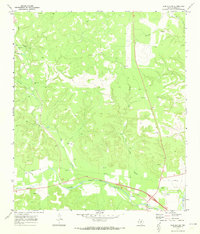 1970 Elm Slough1973 Print · USGSThe Llano River valley in Kimble County is captured here in the early 1970s as ranching and new infrastructure meet. Researchers can locate family landmarks like the Bear Creek Cem and Bolt Ranch alongside the County Airport.2 unique versions available
 - 1974 Map of Junction, 1977 Print
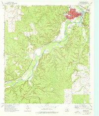 1974 Junction1977 Print · USGSThe confluence of the Llano rivers in the 1970s reveals a growing community centered around the Junction townsite and its riverbanks. Researchers can trace the mid-century footprint of the Texas Tech University Center, find local landmarks like Lovers Leap, and locate the Cem near the city center.
 - 1974 Map of Segovia, 1977 Print
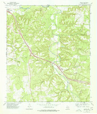 1974 Segovia1977 Print · USGSKimble County in the mid-1970s shows a landscape of deep canyons and evolving roads as the modern highway began to bypass traditional routes. Genealogists and local historians can trace family-named sites like Schrier Cem, Nethery, and the Old Segovia Road.
End of results
Showing maps 1-3 of 3
Frequently asked questions
- What are the different types of historical maps available for Junction?
- What is the oldest map of Junction?
- Where can I purchase historical maps of Junction for my home or office?
- Where can I download high-res historical maps of Junction?
- Are there historical topographic maps available for Junction?
- Is there historical aerial imagery available for Junction?
- Where are historical maps of Junction sourced from?