1950s Maps of King County, Texas
Explore 6 historic maps of King County from the 1950s. These maps offer a rare glimpse into what life looked like during the 1950s — showing old roads, neighborhoods, homes, and landmarks that have changed or disappeared over time.
Whether you're researching your family's past, planning a metal detecting trip, or studying how King County's landscape evolved across the 1950s, these high-resolution maps are a powerful tool for exploring the history of this region.
- Focus on a specific era: All maps on this page are from the 1950s, giving you a focused view of this time period.
- See what’s changed: Compare century-old streets, trails, and buildings to today's modern landscape using overlays and satellite layers.
- Research with precision: Use these maps for genealogy, historical research, land use analysis, or educational projects.
- View, download, or print: Maps are fully viewable online in high resolution, and can be downloaded or printed for your own records.
Start exploring King County's history through authentic maps from the 1950s. This is your window into the past.
King County, TX maps
(6)- 1954 Map of Lubbock, 1958 Print
 1954 Lubbock1958 Print · USGSThe High Plains and Caprock region of West Texas come alive in the mid-1950s, showing a landscape defined by oil discovery and the Brazos River headwaters. Genealogists and historians can trace rail-connected towns like Roaring Springs, find the Pleasant Valley church, or locate family-named landmarks such as Soldier Mound.4 unique versions available
 - 1954 Map of Wichita Falls, 1966 Print
 1954 Wichita Falls1966 Print · USGSNorth Texas in the mid-fifties is captured here as a landscape of expanding oil fields and vital rail corridors. Genealogists and historians can trace family roots through rural landmarks like Bacon Chapel and the rail-side growth of Seymour and Archer City.3 unique versions available
 - 1958 Map of Wichita Falls
 1958 Wichita Falls1958 Print · USGSNorth Texas during the late fifties reveals a landscape defined by the booming petroleum industry and established rail hubs. Researchers can trace the development of Wichita Falls and discover rural landmarks like Barton's Chapel or the Hull-Silk Oil Field.
 - 1958 Map of Pursley House, 1959 Print
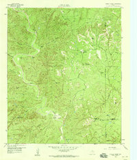 1958 Pursley House1959 Print · USGSThe West Texas ranchlands at the junction of four counties are captured here in the late fifties. Researchers can trace remote homesteads and cattle operations like Pursley House, Beggs Ranch, and Kellar Field Camp.2 unique versions available
 - 1958 Map of Southerland Canyon, 1959 Print
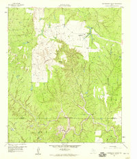 1958 Southerland Canyon1959 Print · USGSCattle ranching in the late fifties defines this rugged boundary between King and Stonewall counties. Researchers can trace historic fence lines and cattle infrastructure around the Bar S Ranch and local landmarks like Haystack Mountain and Southerland Canyon.2 unique versions available
 - 1959 Map of Bob Creek, 1960 Print
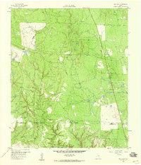 1959 Bob Creek1960 Print · USGSThe King and Stonewall County borderlands are documented here in the late fifties, capturing a period of transition for West Texas ranching. Researchers can locate the Gilberton Cem and trace the Salt Fork Brazos River past the Martin Ranch.2 unique versions available
End of results
Showing maps 1-6 of 6
Top cities of King County
Frequently asked questions
- What are the different types of historical maps available for King County?
- What is the oldest map of King County?
- Where can I purchase historical maps of King County for my home or office?
- Where can I download high-res historical maps of King County?
- Are there historical topographic maps available for King County?
- Is there historical aerial imagery available for King County?
- Where are historical maps of King County sourced from?