Old Maps of King County, Texas for Metal Detecting
Plan your next treasure hunt with 151 historic maps of King County. Find old homesites, ghost towns, trails, and gathering spots that may be lost to time — perfect for identifying promising metal detecting locations.
- Locate forgotten sites: Uncover places like long-lost settlements, abandoned rail lines, or gathering spots.
- Plan better hunts: Use map overlays combined with LiDAR or satellite views to narrow in on historically rich areas.
- Made for detectorists: Thousands of hobbyists use these maps to discover relics, coins, and hidden history.
Use these historic maps to boost your research and find new opportunities beneath the surface of King County.
King County, TX maps
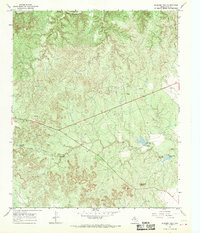
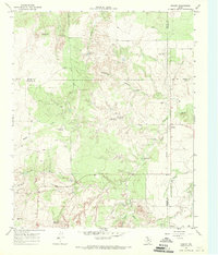
(151)- 1954 Map of Lubbock, 1958 Print
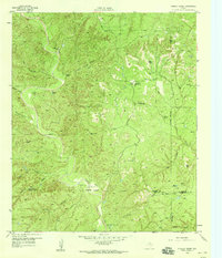
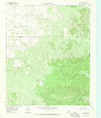
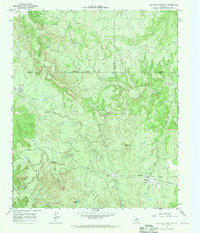
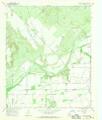
 1954 Lubbock1958 Print · USGSThe High Plains and Caprock region of West Texas come alive in the mid-1950s, showing a landscape defined by oil discovery and the Brazos River headwaters. Genealogists and historians can trace rail-connected towns like Roaring Springs, find the Pleasant Valley church, or locate family-named landmarks such as Soldier Mound.4 unique versions available
 - 1954 Map of Wichita Falls, 1966 Print
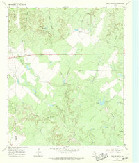
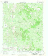
 1954 Wichita Falls1966 Print · USGSNorth Texas in the mid-fifties is captured here as a landscape of expanding oil fields and vital rail corridors. Genealogists and historians can trace family roots through rural landmarks like Bacon Chapel and the rail-side growth of Seymour and Archer City.3 unique versions available
 - 1958 Map of Wichita Falls
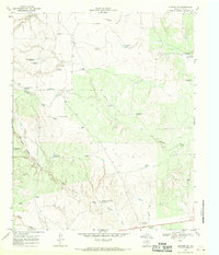
 1958 Wichita Falls1958 Print · USGSNorth Texas during the late fifties reveals a landscape defined by the booming petroleum industry and established rail hubs. Researchers can trace the development of Wichita Falls and discover rural landmarks like Barton's Chapel or the Hull-Silk Oil Field.
 - 1958 Map of Pursley House, 1959 Print
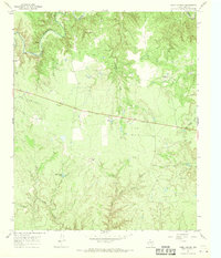
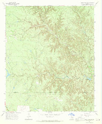
 1958 Pursley House1959 Print · USGSThe West Texas ranchlands at the junction of four counties are captured here in the late fifties. Researchers can trace remote homesteads and cattle operations like Pursley House, Beggs Ranch, and Kellar Field Camp.2 unique versions available
 - 1958 Map of Southerland Canyon, 1959 Print
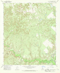
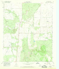
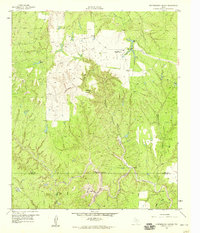 1958 Southerland Canyon1959 Print · USGSCattle ranching in the late fifties defines this rugged boundary between King and Stonewall counties. Researchers can trace historic fence lines and cattle infrastructure around the Bar S Ranch and local landmarks like Haystack Mountain and Southerland Canyon.2 unique versions available
 - 1959 Map of Bob Creek, 1960 Print
 1959 Bob Creek1960 Print · USGSThe King and Stonewall County borderlands are documented here in the late fifties, capturing a period of transition for West Texas ranching. Researchers can locate the Gilberton Cem and trace the Salt Fork Brazos River past the Martin Ranch.2 unique versions available
 - 1966 Map of Ox Yoke Creek, 1969 Print
 1966 Ox Yoke Creek1969 Print · USGSKing County ranching and energy development are captured in the mid-sixties as the petroleum industry expanded through the river breaks. Researchers can trace historic creek crossings at a Ford or locate old ranching landmarks like Jerrys Tank and Corral.2 unique versions available
 - 1966 Map of Chalk SW, 1969 Print
 1966 Chalk SW1969 Print · USGSKing and Cottle counties were defined by cattle ranching and early oil exploration during the mid-sixties. Researchers can trace the boundaries of the J Y Ranch West Camp, locate the Shinnery Cem, and follow the Middle Fork Wichita River.
 - 1966 Map of Big Four Ranch, 1969 Print
 1966 Big Four Ranch1969 Print · USGSSpanning the tri-county border of Foard, King, and Knox in the mid-sixties, this map reveals the ranching heart of North Texas. Genealogists and researchers can trace family-named landmarks like Masterson and the historic Big Four Ranch among the forks of the Wichita River.
 - 1966 Map of J Y Ranch, 1969 Print
 1966 J Y Ranch1969 Print · USGSRanching and oil production define this King County landscape during the mid-1960s. Genealogists and historians can trace the vast J Y Ranch property, locate the Bateman Oil Field, and follow old pack trails along the South Wichita River.2 unique versions available
 - 1966 Map of Maverick Flat, 1969 Print
 1966 Maverick Flat1969 Print · USGSRanching outposts and rugged canyonlands define this portion of North Texas in the mid-sixties. Researchers can trace land use at the Alexander Ranch (Headquarters) or locate vanished locales like Hog Camp and Glover along the South Wichita River.2 unique versions available
 - 1966 Map of Lowrance Mountain, 1969 Print
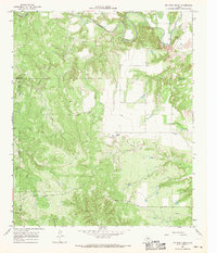
 1966 Lowrance Mountain1969 Print · USGSThe Wichita River breaks of King County are captured here in the mid-1960s, showing a remote ranching landscape transitioning into the oil and gas era. Researchers can locate the Lowrance Ranch and its landing strip or trace water sources like Pouring Spring and Marys Lake.2 unique versions available
 - 1967 Map of Cedar Mountain, 1969 Print
 1967 Cedar Mountain1969 Print · USGSThe ranchlands of Knox and King counties appear here in the late sixties, showing a landscape of family-run operations and intricate canyon systems. Researchers can trace land use through named features like Williams Ranch, Croton Windmill, and the Prospect site.2 unique versions available
 - 1967 Map of Guthrie NW, 1970 Print
 1967 Guthrie NW1970 Print · USGSRanching life in King County during the late 1960s is centered here on the 6666 Ranch North Camp. Researchers can trace the ranch's water infrastructure through family-named sites like Flippen Windmill and the deep reaches of Long Canyon.2 unique versions available
 - 1967 Map of Dark Canyon, 1970 Print
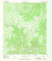
 1967 Dark Canyon1970 Print · USGSKing County ranching is captured here in the late sixties, showing the rugged breaks between the South Wichita River and Dark Canyon. Researchers can trace old stock operations at Bateman Ranch, Eight Camp, and the historic Pickett Pens.2 unique versions available
 - 1967 Map of Knox City NW, 1970 Print
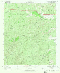
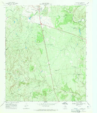
 1967 Knox City NW1970 Print · USGSThe Brazos River valley in the late sixties reveals a landscape of petroleum exploration and winding creek beds along the Knox and King county lines. Genealogists and researchers can locate the settlement of Hamilton, trace the route of Mc Faddin Lane, and identify numerous early Oil Wells.
 - 1967 Map of Fourmile Hill, 1970 Print
 1967 Fourmile Hill1970 Print · USGSKing County ranching country is captured here in the late sixties, showing the vast water-well network of the legendary Four Sixes. Trace local landmarks like the 6666 Ranch Airfield, the settlement at Finney, and the heights of Fourmile Hill.2 unique versions available
 - 1967 Map of Kiowa Peak NW, 1970 Print
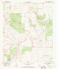
 1967 Kiowa Peak NW1970 Print · USGSKing and Stonewall counties appear as a network of rugged canyons and ranch lands in the late sixties. Trace the early industrial footprint of the region through labeled Oil Wells, the J M A Ranch, and seasonal water at Pen Branch Tank.2 unique versions available
 - 1967 Map of Kiowa Peak NE, 1970 Print
 1967 Kiowa Peak NE1970 Print · USGSThe King and Stonewall County line in the late sixties reveals a landscape of industrial energy expansion along the Brazos River. Researchers can trace the mid-century oil infrastructure through a Refinery, a Pumping Sta, and a remote Landing Strip.2 unique versions available
 - 1967 Map of Buzzard Peak, 1970 Print
 1967 Buzzard Peak1970 Print · USGSKing County was a landscape of wide-open ranching and rising oil production in the late 1960s. Researchers can trace cattle-country landmarks like the Ross Ranch and Moorhouse Ranch or locate industrial sites including the Oil Field.2 unique versions available
 - 1968 Map of Grow, 1970 Print
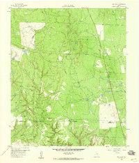
 1968 Grow1970 Print · USGSThe West Texas ranchlands of King County are captured here in the late sixties, where the North Wichita River meets a network of rural outposts. Genealogists and historians can trace local life at the Finney Community Center, Grow, and the settlement of Richards.
 - 1968 Map of Pitchfork Ranch, 1970 Print
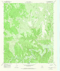
 1968 Pitchfork Ranch1970 Print · USGSRanching life on the Rolling Plains is captured here in the late sixties along the Dickens and King County border. Researchers can trace the water sources and outposts critical to the Pitchfork Ranch, including Humble Windmill and Devils Playground Windmill.2 unique versions available
 - 1968 Map of Buffalo Creek, 1970 Print
 1968 Buffalo Creek1970 Print · USGSThe ranchlands along the Cottle and King county line are captured here in the late 1960s as they are carved by the North Wichita River. Genealogists and historians can trace family-named landmarks like Snakey Futch Windmill, Camp Hollar Windmill, and the settlement of Delwin.2 unique versions available
 - 1968 Map of Dumont, 1970 Print
 1968 Dumont1970 Print · USGSThe West Texas ranching country near the Dickens and King county line was a network of seasonal draws and vital water sources in the late sixties. Trace the distribution of livestock windmills like Threeway Windmill and the settlement at Dumont near the North Wichita River.2 unique versions available
 - 1968 Map of Guthrie, 1971 Print
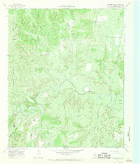
 1968 Guthrie1971 Print · USGSGuthrie and the cattle-grazing lands of King County are captured here in the late sixties, when the local economy relied on a sparse but critical network of water sources. Genealogists and historians can locate specific ranching landmarks like the Old Wooden Town Windmill and Spring Canyon Trap Windmill.2 unique versions available
Showing maps 1-25 of 151
Top cities of King County
Frequently asked questions
- What are the different types of historical maps available for King County?
- What is the oldest map of King County?
- Where can I purchase historical maps of King County for my home or office?
- Where can I download high-res historical maps of King County?
- Are there historical topographic maps available for King County?
- Is there historical aerial imagery available for King County?
- Where are historical maps of King County sourced from?