
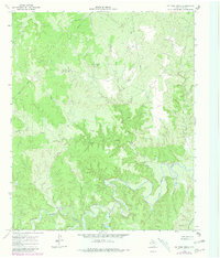
1966 Map of Ox Yoke Creek
USGS Topo · Published 1969About this map
South Wichita River meanders across this King County landscape, carving a deep valley fed by numerous seasonal drainages during the mid-1960s. The terrain is defined by the erosion patterns of Ox Yoke Creek and Bird Creek, which descend from the high plains into the river breaks. This was a working ranchland environment during the survey era, evidenced by the scattered infrastructure of the petroleum and cattle industries. Numerous Drill Hole sites and a Gas Well appear alongside a long north-south Pipeline, while localized ranch features like Jerrys Tank and a Corral mark the management of livestock. Geologically, the map captures the transition from open grazing land to the steep walls of Big Getaway Canyon, with several Ford crossings providing the only passage across the shifting riverbed and creeks like Dikes Cr.
Find a feature on this map
14 named features on this map. Tap any name to fly to it.
Don’t see what you’re looking for? This feature index may not catch every label — zoom into the map to look around manually.
Map Details
Editions of this 1966 Ox Yoke Creek Map
2 editions found
Other maps of this area

1954 · Lubbock
USGS Topo · 1:250,000

1954 · Wichita Falls
USGS Topo · 1:250,000

1958 · Wichita Falls
USGS Topo · 1:250,000

1966 · Chalk SW
USGS Topo · 1:24,000

1966 · Big Four Ranch
USGS Topo · 1:24,000

1966 · J Y Ranch
USGS Topo · 1:24,000

1966 · Maverick Flat
USGS Topo · 1:24,000

1966 · Lowrance Mountain
USGS Topo · 1:24,000

1967 · Cedar Mountain
USGS Topo · 1:24,000

1967 · Dark Canyon
USGS Topo · 1:24,000