
1966 Map of J Y Ranch
USGS Topo · Published 1969About this map
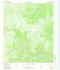
The J Y Ranch and its extensive grazing lands dominate this King County landscape, which is defined by the winding hydrology of the Middle Fork Wichita River and the South Wichita River. This mid-century survey captures the ranching operations at a time when the J Y Ranch South Camp served as a key outpost in the southern section of the property. The terrain is deeply carved by drainage systems like Willow Creek and Bird Creek, illustrating the complex erosional patterns of the Texas Rolling Plains.
Find a feature on this map
16 named features on this map. Tap any name to fly to it.
Don’t see what you’re looking for? This feature index may not catch every label — zoom into the map to look around manually.
Map Details
Editions of this 1966 J Y Ranch Map
2 editions found
Other maps of this area

1954 · Lubbock
USGS Topo · 1:250,000

1966 · Ox Yoke Creek
USGS Topo · 1:24,000

1966 · Chalk SW
USGS Topo · 1:24,000

1966 · Lowrance Mountain
USGS Topo · 1:24,000

1967 · Dark Canyon
USGS Topo · 1:24,000

1967 · Fourmile Hill
USGS Topo · 1:24,000
1967 · Buzzard Peak
USGS Topo · 1:24,000

1968 · Grow
USGS Topo · 1:24,000

1968 · Guthrie
USGS Topo · 1:24,000

1985 · Dickens
USGS Topo · 1:100,000