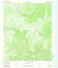
1966 Map of J Y Ranch
USGS Topo · Published 1981About this map
The South Wichita River and the Middle Fork Wichita River define this ranching and petroleum landscape in King County. In the mid-1960s, the vast J Y Ranch dominates the terrain, supported by the J Y Ranch South Camp and the J Y Masterson Landing Field. Evidence of industrial activity is centered on the Bateman Oil Field in the southwest, where numerous Oil Wells and Drill Holes are noted alongside a growing network of pipelines. Transportation across this remote country is limited to a handful of routes, including the Newman Trail and several jeep trails, reflecting a time when the region was primarily accessed for cattle operations and oil exploration. Revisions from 1979 purple-ink updates show continued development in the area's resource extraction infrastructure.
Find a feature on this map
16 named features on this map. Tap any name to fly to it.
Don’t see what you’re looking for? This feature index may not catch every label — zoom into the map to look around manually.
Map Details
Editions of this 1966 J Y Ranch Map
2 editions found
Other maps of this area

1954 · Lubbock
USGS Topo · 1:250,000

1966 · Ox Yoke Creek
USGS Topo · 1:24,000

1966 · Chalk SW
USGS Topo · 1:24,000

1966 · J Y Ranch
USGS Topo · 1:24,000

1966 · Lowrance Mountain
USGS Topo · 1:24,000

1967 · Dark Canyon
USGS Topo · 1:24,000

1967 · Fourmile Hill
USGS Topo · 1:24,000
1967 · Buzzard Peak
USGS Topo · 1:24,000

1968 · Grow
USGS Topo · 1:24,000

1968 · Guthrie
USGS Topo · 1:24,000