
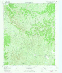
1966 Map of Lowrance Mountain
USGS Topo · Published 1969About this map
The deeply dissected breaks of the Wichita River watershed define this landscape in King County during the mid-1960s. The terrain is characterized by intricate drainage patterns and prominent elevations like Wild Horse Mountain and Lowrance Mountain, which rise above the surrounding canyons and river forks. Human activity is largely concentrated around ranching and burgeoning industrial infrastructure, as evidenced by the presence of the Lowrance Ranch and its associated Landing Strip.
Find a feature on this map
28 named features on this map. Tap any name to fly to it.
Don’t see what you’re looking for? This feature index may not catch every label — zoom into the map to look around manually.
Map Details
Editions of this 1966 Lowrance Mountain Map
2 editions found
Other maps of this area

1954 · Lubbock
USGS Topo · 1:250,000

1954 · Wichita Falls
USGS Topo · 1:250,000

1958 · Wichita Falls
USGS Topo · 1:250,000

1966 · Ox Yoke Creek
USGS Topo · 1:24,000

1966 · Chalk SW
USGS Topo · 1:24,000

1966 · Big Four Ranch
USGS Topo · 1:24,000

1966 · J Y Ranch
USGS Topo · 1:24,000

1966 · Maverick Flat
USGS Topo · 1:24,000

1968 · Y Ranch
USGS Topo · 1:24,000
1968 · Boiling Spring
USGS Topo · 1:24,000