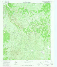
1966 Map of Lowrance Mountain
USGS Topo · Published 1981About this map
Lowrance Ranch and the industrial infrastructure of the Juniper Gas Field anchor this mid-1960s Texas landscape where King, Foard, and Cottle counties converge. The terrain is deeply defined by the winding course of the Middle Fork Wichita River, which carves through a region marked by prominent elevations like Lowrance Mountain and Wild Horse Mountain. Scattered gas wells and drill holes indicate the active energy extraction of the era, supported by a network of pipelines and a dedicated Pumping Station.
Find a feature on this map
23 named features on this map. Tap any name to fly to it.
Don’t see what you’re looking for? This feature index may not catch every label — zoom into the map to look around manually.
Map Details
Editions of this 1966 Lowrance Mountain Map
2 editions found
Other maps of this area

1954 · Lubbock
USGS Topo · 1:250,000

1954 · Wichita Falls
USGS Topo · 1:250,000

1958 · Wichita Falls
USGS Topo · 1:250,000

1966 · Ox Yoke Creek
USGS Topo · 1:24,000

1966 · Chalk SW
USGS Topo · 1:24,000

1966 · Big Four Ranch
USGS Topo · 1:24,000

1966 · J Y Ranch
USGS Topo · 1:24,000

1966 · Maverick Flat
USGS Topo · 1:24,000

1966 · Lowrance Mountain
USGS Topo · 1:24,000

1968 · Y Ranch
USGS Topo · 1:24,000