
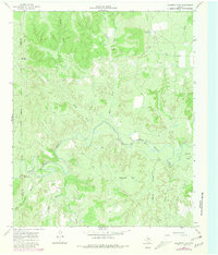
1966 Map of Maverick Flat
USGS Topo · Published 1969About this map
The South Wichita River carves a winding path through the broken canyonlands of the Rolling Plains in this mid-1960s landscape. Ranching operations and isolated outposts define the human presence here, anchored by the Alexander Ranch (Headquarters) and the Wells settlement near the northern boundary. The terrain is deeply dissected, characterized by numerous drainages such as Honey Creek and Salt Creek that feed into the river valley.
Find a feature on this map
24 named features on this map. Tap any name to fly to it.
Don’t see what you’re looking for? This feature index may not catch every label — zoom into the map to look around manually.
Map Details
Editions of this 1966 Maverick Flat Map
2 editions found
Other maps of this area

1954 · Lubbock
USGS Topo · 1:250,000

1954 · Wichita Falls
USGS Topo · 1:250,000

1958 · Wichita Falls
USGS Topo · 1:250,000

1966 · Truscott North
USGS Topo · 1:24,000

1966 · Truscott South
USGS Topo · 1:24,000

1966 · Ox Yoke Creek
USGS Topo · 1:24,000

1966 · Big Four Ranch
USGS Topo · 1:24,000

1966 · Lowrance Mountain
USGS Topo · 1:24,000

1967 · Cedar Mountain
USGS Topo · 1:24,000

1967 · Benjamin
USGS Topo · 1:24,000