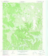
1966 Map of Ox Yoke Creek
USGS Topo · Published 1981About this map
The South Wichita River meanders through this portion of King County, defining a landscape of deep drainages and cattle country as it appeared in the mid-1960s. The map illustrates a network of named waterways feeding into the river, including Ox Yoke Creek, Bird Creek, and Spring Creek. Human presence is marked primarily by ranching infrastructure and energy exploration, with numerous scattered drill holes and a Gas Well indicating the area's geological utility. Land use is further characterized by the presence of Jerrys Tank and a Corral, alongside a utility pipeline that traverses the northern terrain. This survey, updated with 1979 aerial photography, documents the transition of this rural territory toward more intensive resource extraction while maintaining its fundamental character as open rangeland.
Find a feature on this map
13 named features on this map. Tap any name to fly to it.
Don’t see what you’re looking for? This feature index may not catch every label — zoom into the map to look around manually.
Map Details
Editions of this 1966 Ox Yoke Creek Map
2 editions found
Other maps of this area

1954 · Lubbock
USGS Topo · 1:250,000

1954 · Wichita Falls
USGS Topo · 1:250,000

1958 · Wichita Falls
USGS Topo · 1:250,000

1966 · Ox Yoke Creek
USGS Topo · 1:24,000

1966 · Chalk SW
USGS Topo · 1:24,000

1966 · Big Four Ranch
USGS Topo · 1:24,000

1966 · J Y Ranch
USGS Topo · 1:24,000

1966 · Maverick Flat
USGS Topo · 1:24,000

1966 · Lowrance Mountain
USGS Topo · 1:24,000

1967 · Cedar Mountain
USGS Topo · 1:24,000