1900s (20th Century) Maps of Leander, Texas
Explore 8 historic maps of Leander from the 1900s (20th Century). These maps offer a rare glimpse into what life looked like during the 1900s — showing old roads, neighborhoods, homes, and landmarks that have changed or disappeared over time.
Whether you're researching your family's past, planning a metal detecting trip, or studying how Leander's landscape evolved across the 1900s, these high-resolution maps are a powerful tool for exploring the history of this region.
- Focus on a specific era: All maps on this page are from the 1900s, giving you a focused view of this time period.
- See what’s changed: Compare century-old streets, trails, and buildings to today's modern landscape using overlays and satellite layers.
- Research with precision: Use these maps for genealogy, historical research, land use analysis, or educational projects.
- View, download, or print: Maps are fully viewable online in high resolution, and can be downloaded or printed for your own records.
Start exploring Leander's history through authentic maps from the 1900s. This is your window into the past.
Leander, TX maps
(8)- 1954 Map of Austin, 1964 Print
 1954 Austin1964 Print · USGSCentral Texas is captured during a period of steady growth as the capital city and its neighboring farm towns began to modernize. Researchers can trace historic rail corridors like the Southern Pacific RR or locate landmarks such as Bergstrom Air Force Base and Pilot Knob.4 unique versions available
 - 1962 Map of Liberty Hill, 1966 Print
 1962 Liberty Hill1966 Print · USGSThe rural landscape of Liberty Hill and Seward Junction is captured in the early sixties as the railroad era still shaped the hill country. Researchers can find family-named landmarks and old burial grounds like Buck Cem and Liberty Hill Cem.2 unique versions available
 - 1962 Map of Leander, 1966 Print
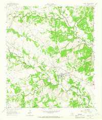
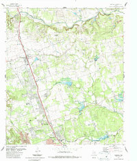
 1962 Leander1966 Print · USGSCentral Texas settlements and Hill Country ranch land thrive along the rail line during the early sixties. Genealogists can trace family names at Bagdad Cem and White Stone, or locate the Independent Sch near the Southern Pacific tracks.4 unique versions available
 - 1962 Map of Nameless, 1966 Print
 1962 Nameless1966 Print · USGSThe rural Texas Hill Country comes to life in the 1960s, showing the intersection of Travis and Williamson counties. Genealogists can locate family landmarks like Miller Cem, the small settlement of Nameless, and the sprawling Post Oak Ridge.2 unique versions available
 - 1962 Map of Leander NE, 1966 Print
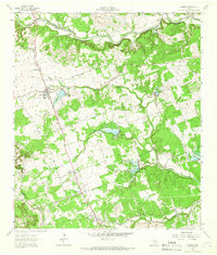
 1962 Leander NE1966 Print · USGSThe North Fork of the San Gabriel River system defines this Williamson County landscape in the early sixties. Genealogists can trace family names at Anderson Cem and Bullion Cem, or locate landmarks like Union Chapel and Seward Junction.4 unique versions available
 - 1985 Map of Taylor, 1986 Print
 1985 Taylor1986 Print · USGSWilliamson and Bell counties in the mid-eighties reveal a landscape where the cattle and cotton economy met burgeoning rail infrastructure. Genealogists and historians can trace the paths of the Missouri Pacific railroad through unique hamlets like Ding Dong, Frame Switch, and Beyersville.2 unique versions available
 - 1986 Map of Nameless
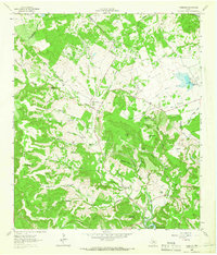
 1986 Nameless1986 Print · USGSThe Texas Hill Country north of Lake Travis comes into focus during the mid-eighties, showing a rural landscape of ranch roads and limestone ridges. Genealogists and historians can trace family-named sites like Heinatz Flat, Huddleston Cem, and the uniquely named settlement of Nameless.
 - 1987 Map of Leander
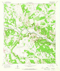
 1987 Leander1987 Print · USGSGrowing along the railroad in the late eighties, this area shows the transition from rural Williamson County to suburban expansion. Genealogists can trace family roots at Bagdad Cem and Upchurch Cem, while historians can locate old stops like White Stone and Walkerton.2 unique versions available
End of results
Showing maps 1-8 of 8
Top cities near Leander
- Austin historical maps
- Round Rock historical maps
- Georgetown historical maps
- Pflugerville historical maps
- Cedar Park historical maps
- Lakeway historical maps
See more
Top neighborhoods of Leander
- Nameless historical maps
- Benbrook Ranch historical maps
- Bluffview historical maps
- Bryson historical maps
- Edgewood historical maps
- Horizon Lake historical maps
See more
Frequently asked questions
- What are the different types of historical maps available for Leander?
- What is the oldest map of Leander?
- Where can I purchase historical maps of Leander for my home or office?
- Where can I download high-res historical maps of Leander?
- Are there historical topographic maps available for Leander?
- Is there historical aerial imagery available for Leander?
- Where are historical maps of Leander sourced from?