1900s (20th Century) Maps of Hardin, Texas
Explore 10 historic maps of Hardin from the 1900s (20th Century). These maps offer a rare glimpse into what life looked like during the 1900s — showing old roads, neighborhoods, homes, and landmarks that have changed or disappeared over time.
Whether you're researching your family's past, planning a metal detecting trip, or studying how Hardin's landscape evolved across the 1900s, these high-resolution maps are a powerful tool for exploring the history of this region.
- Focus on a specific era: All maps on this page are from the 1900s, giving you a focused view of this time period.
- See what’s changed: Compare century-old streets, trails, and buildings to today's modern landscape using overlays and satellite layers.
- Research with precision: Use these maps for genealogy, historical research, land use analysis, or educational projects.
- View, download, or print: Maps are fully viewable online in high resolution, and can be downloaded or printed for your own records.
Start exploring Hardin's history through authentic maps from the 1900s. This is your window into the past.
Hardin, TX maps
(10)- 1943 Map of Liberty
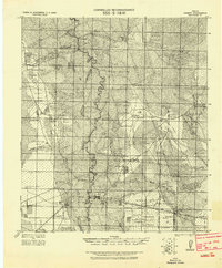 1943 Liberty1943 Print · USGSLiberty and the surrounding Big Thicket are documented here during the early twentieth-century boom in timber and oil. Researchers can locate vanished landmarks such as the Yellow School House, trace family lands like Mears Ranch, and follow the path of the Old Tram through the river bottomlands.
 - 1954 Map of Beaumont, 1964 Print
 1954 Beaumont1964 Print · USGSSoutheast Texas in the mid-fifties reveals a landscape of massive national forests, emerging reservoirs, and a booming oil economy. Genealogists and researchers can trace rural settlements like Dallardsville and Village Mills or locate early drilling sites at Sour Lake Oil Field.3 unique versions available
 - 1955 Map of Daisetta, 1956 Print
 1955 Daisetta1956 Print · USGSLiberty County was undergoing an industrial transition in the 1950s as oil fields and drainage canals reshaped the coastal prairie. Researchers can trace the development of salt dome operations near Daisetta or locate rural landmarks like Ames Cem and Sacred Heart Ch.3 unique versions available
 - 1955 Map of Liberty, 1957 Print
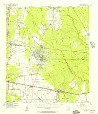
 1955 Liberty1957 Print · USGSLiberty and Dayton thrived at the crossroads of the Trinity River and major rail lines during the mid-fifties. Genealogists and historians can trace family landmarks like Magnolia Cem, Daniel Ranch, and schools like Colbert High Sch.2 unique versions available
 - 1957 Map of Beaumont
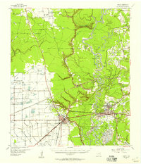
 1957 Beaumont1957 Print · USGSSoutheast Texas in the mid-fifties is defined by the timber-rich lands between the Trinity River and Beaumont. Trace the history of the Alabama and Coushatti Indian Reservation or locate early campus sites like Prairie View College.
 - 1984 Map of Beaumont
 1984 Beaumont1984 Print · USGSSoutheast Texas in the late seventies and early eighties shows a landscape of expanding reservoirs and deep timber industry. Researchers can trace the development of the Sam Houston National Forest or locate regional landmarks like Grabbs Prairie and the Wynne State Prison Farm.3 unique versions available
 - 1984 Map of Hardin, 1985 Print
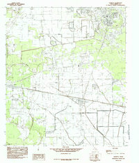
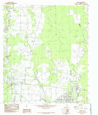 1984 Hardin1985 Print · USGSIn the mid-1980s, the oil-rich coastal plains of East Texas were a grid of industrial pipelines and rural settlements. Genealogists and researchers can trace the limits of Hardin, Hull, and the Tanner Settlement alongside the expansive Daisetta Swamp.
 - 1984 Map of Daisetta, 1985 Print
 1984 Daisetta1985 Print · USGSCoastal Texas industry and rural life meet in this mid-1980s survey of Liberty County. Researchers can trace the footprint of the local energy sector at the Oil Field or locate community landmarks like the Rodeo Ground and Cem.
 - 1984 Map of Capers Ridge, 1986 Print
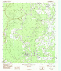 1984 Capers Ridge1986 Print · USGSThe Trinity River bottoms in the late seventies reveal a complex landscape of oxbow lakes and winding bayous. Genealogists and local historians can trace the geography around Knight, the Barrett Trail, and water bodies like New Old River Lake or Hardin Lake.
 - 1986 Map of Beaumont
 1986 Beaumont1986 Print · USGSThe East Texas piney woods and coastal prairies are captured here in the mid-eighties, a period of established energy production and conservation. Researchers can trace the industrial footprint of the Oil and Gas Field near Daisetta and Batson, or locate family sites at Graveyard Hill Cem.
End of results
Showing maps 1-10 of 10
Top cities near Hardin
- Liberty historical maps
- Dayton historical maps
- Daisetta historical maps
- Ames historical maps
- Kenefick historical maps
- Hull historical maps
See more
Frequently asked questions
- What are the different types of historical maps available for Hardin?
- What is the oldest map of Hardin?
- Where can I purchase historical maps of Hardin for my home or office?
- Where can I download high-res historical maps of Hardin?
- Are there historical topographic maps available for Hardin?
- Is there historical aerial imagery available for Hardin?
- Where are historical maps of Hardin sourced from?