1900s (20th Century) Maps of Groesbeck, Texas
Explore 9 historic maps of Groesbeck from the 1900s (20th Century). These maps offer a rare glimpse into what life looked like during the 1900s — showing old roads, neighborhoods, homes, and landmarks that have changed or disappeared over time.
Whether you're researching your family's past, planning a metal detecting trip, or studying how Groesbeck's landscape evolved across the 1900s, these high-resolution maps are a powerful tool for exploring the history of this region.
- Focus on a specific era: All maps on this page are from the 1900s, giving you a focused view of this time period.
- See what’s changed: Compare century-old streets, trails, and buildings to today's modern landscape using overlays and satellite layers.
- Research with precision: Use these maps for genealogy, historical research, land use analysis, or educational projects.
- View, download, or print: Maps are fully viewable online in high resolution, and can be downloaded or printed for your own records.
Start exploring Groesbeck's history through authentic maps from the 1900s. This is your window into the past.
Groesbeck, TX maps
(9)- 1920 Map of Mexia
 1920 Mexia1920 Print · USGSLimestone and Freestone counties are shown here just after the Great War, during a period of significant railway expansion and rural settlement. Researchers can trace the routes of the Houston and Texas Central and locate sites like Cotton Gin, Pt. Enterprise, and Duck Lake.
 - 1954 Map of Waco, 1964 Print
 1954 Waco1964 Print · USGSCentral Texas during the mid-fifties shows a landscape defined by the expansion of Fort Hood Military Reservation and the Brazos river system. Trace the rail lines and early airfields like James Connally Air Force Base and settlements like Temple or McGregor.2 unique versions available
 - 1955 Map of Waco
 1955 Waco1955 Print · USGSCentral Texas at the peak of the Cold War reveals a landscape defined by military expansion and major water projects. Researchers can trace the footprints of Fort Hood, the waters of Lake Waco, and regional hubs like Temple or Mexia.
 - 1957 Map of Groesbeck
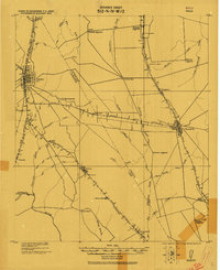
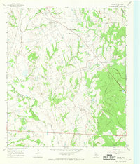
 1957 Groesbeck1957 Print · USGSLimestone County at the turn of the century shows a dense web of railroad stops and rural post offices centered on the Navasota River. Genealogists and historians can locate family sites near Honest Ridge School, Springfield, and the Reunion Grounds.
 - 1960 Map of Groesbeck, 1961 Print
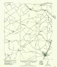
 1960 Groesbeck1961 Print · USGSLimestone County at the start of the sixties revolves around the rail hub of Groesbeck and the waters of the Navasota River. Genealogists can trace family roots at Faulkenberry Cem and the site of Fort Parker (Historical).2 unique versions available
 - 1966 Map of Thornton, 1968 Print
 1966 Thornton1968 Print · USGSThornton and the surrounding Limestone County ranch lands are captured in the mid-sixties, centered on the Southern Pacific railroad. Genealogists can trace numerous family burial sites, including Pippin, Phifer, and Pleasant Grove cemeteries.
 - 1966 Map of Fallon, 1969 Print
 1966 Fallon1969 Print · USGSLimestone County in the mid-sixties remained a rural expanse of winding river bottoms and small community hubs. Local historians can trace the old rail networks and family burial sites like Doyle Cem, Box Car Center, and the crossing at Long Bridge.2 unique versions available
 - 1985 Map of Marlin
 1985 Marlin1985 Print · USGSMid-century Texas agriculture and transit converge here during the mid-1980s, centered on the Brazos River corridor. Genealogists can locate family sites near Tidwell Prairie or trace the Missouri Pacific RR through Bremond and Kosse.2 unique versions available
 - 1985 Map of Mexia
 1985 Mexia1985 Print · USGSLimestone and Freestone counties are shown in the mid-eighties as centers of rail-linked commerce and growing reservoir systems. Researchers can trace the grounds of Mexia State School, the campus of Westminster College, and historic Fort Parker.2 unique versions available
End of results
Showing maps 1-9 of 9
Top cities near Groesbeck
- Mexia historical maps
- Teague historical maps
- Coolidge historical maps
- Thornton historical maps
- Kosse historical maps
- Tehuacana historical maps
Frequently asked questions
- What are the different types of historical maps available for Groesbeck?
- What is the oldest map of Groesbeck?
- Where can I purchase historical maps of Groesbeck for my home or office?
- Where can I download high-res historical maps of Groesbeck?
- Are there historical topographic maps available for Groesbeck?
- Is there historical aerial imagery available for Groesbeck?
- Where are historical maps of Groesbeck sourced from?