1900-1909 Maps of Field Creek, Texas
Explore 2 historic maps of Field Creek from 1900-1909. These maps offer a rare glimpse into what life looked like during the 1900s — showing old roads, neighborhoods, homes, and landmarks that have changed or disappeared over time.
Whether you're researching your family's past, planning a metal detecting trip, or studying how Field Creek's landscape evolved across the 1900s, these high-resolution maps are a powerful tool for exploring the history of this region.
- Focus on a specific era: All maps on this page are from the 1900s, giving you a focused view of this time period.
- See what’s changed: Compare century-old streets, trails, and buildings to today's modern landscape using overlays and satellite layers.
- Research with precision: Use these maps for genealogy, historical research, land use analysis, or educational projects.
- View, download, or print: Maps are fully viewable online in high resolution, and can be downloaded or printed for your own records.
Start exploring Field Creek's history through authentic maps from the 1900s. This is your window into the past.
Field Creek, TX maps
(2)- 1904 Map of Llano
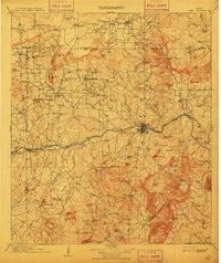
 1904 Llano1904 Print · USGSThe Texas Hill Country around the turn of the century centered on the rail hub of Llano and the winding Llano River. Genealogists can trace early homesteads like Kuykendall's Ranch and locate remote landmarks such as Hesterville Church and the Iron Mine.
 - 1909 Map of Llano
 1909 Llano1909 Print · USGSCentral Texas at the first decade of the new century shows a landscape of cattle ranches and growing rail towns. Genealogists can locate family landmarks such as Atkinson's Ranch, Oxford, and rural social centers like Kennedy School or Wooten Church.3 unique versions available
End of results
Showing maps 1-2 of 2
Top cities near Field Creek
Frequently asked questions
- What are the different types of historical maps available for Field Creek?
- What is the oldest map of Field Creek?
- Where can I purchase historical maps of Field Creek for my home or office?
- Where can I download high-res historical maps of Field Creek?
- Are there historical topographic maps available for Field Creek?
- Is there historical aerial imagery available for Field Creek?
- Where are historical maps of Field Creek sourced from?