1950s Maps of Slaton-Bean, Lubbock
Explore 3 historic maps of Slaton-Bean from the 1950s. These maps offer a rare glimpse into what life looked like during the 1950s — showing old roads, neighborhoods, homes, and landmarks that have changed or disappeared over time.
Whether you're researching your family's past, planning a metal detecting trip, or studying how Slaton-Bean's landscape evolved across the 1950s, these high-resolution maps are a powerful tool for exploring the history of this region.
- Focus on a specific era: All maps on this page are from the 1950s, giving you a focused view of this time period.
- See what’s changed: Compare century-old streets, trails, and buildings to today's modern landscape using overlays and satellite layers.
- Research with precision: Use these maps for genealogy, historical research, land use analysis, or educational projects.
- View, download, or print: Maps are fully viewable online in high resolution, and can be downloaded or printed for your own records.
Start exploring Slaton-Bean's history through authentic maps from the 1950s. This is your window into the past.
Slaton-Bean, Lubbock maps
(3)- 1954 Map of Lubbock, 1958 Print
 1954 Lubbock1958 Print · USGSThe High Plains and Caprock region of West Texas come alive in the mid-1950s, showing a landscape defined by oil discovery and the Brazos River headwaters. Genealogists and historians can trace rail-connected towns like Roaring Springs, find the Pleasant Valley church, or locate family-named landmarks such as Soldier Mound.4 unique versions available
 - 1957 Map of Lubbock East, 1958 Print
 1957 Lubbock East1958 Print · USGSLubbock emerges as a major West Texas center in the late fifties, showcasing the city's expansion alongside the Double Mountain Fork. Researchers can locate mid-century institutions like Texas Technological College, the City Cemetery, and Mac Kenzie State Park.4 unique versions available
 - 1957 Map of Lubbock, 1958 Print
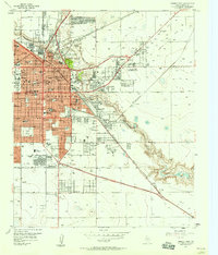
 1957 Lubbock1958 Print · USGSLubbock and its surrounding High Plains communities are captured here in the late fifties during a period of steady growth. Researchers can trace local genealogy and land use through landmarks like City Cemetery, Antioch Sch, and the Lubbock Municipal Airport.
End of results
Showing maps 1-3 of 3
Frequently asked questions
- What are the different types of historical maps available for Slaton-Bean?
- What is the oldest map of Slaton-Bean?
- Where can I purchase historical maps of Slaton-Bean for my home or office?
- Where can I download high-res historical maps of Slaton-Bean?
- Are there historical topographic maps available for Slaton-Bean?
- Is there historical aerial imagery available for Slaton-Bean?
- Where are historical maps of Slaton-Bean sourced from?