1970s Maps of Wolfforth, Texas
Explore 2 historic maps of Wolfforth from the 1970s. These maps offer a rare glimpse into what life looked like during the 1970s — showing old roads, neighborhoods, homes, and landmarks that have changed or disappeared over time.
Whether you're researching your family's past, planning a metal detecting trip, or studying how Wolfforth's landscape evolved across the 1970s, these high-resolution maps are a powerful tool for exploring the history of this region.
- Focus on a specific era: All maps on this page are from the 1970s, giving you a focused view of this time period.
- See what’s changed: Compare century-old streets, trails, and buildings to today's modern landscape using overlays and satellite layers.
- Research with precision: Use these maps for genealogy, historical research, land use analysis, or educational projects.
- View, download, or print: Maps are fully viewable online in high resolution, and can be downloaded or printed for your own records.
Start exploring Wolfforth's history through authentic maps from the 1970s. This is your window into the past.
Wolfforth, TX maps
(2)- 1976 Map of Wolfforth SE, 1978 Print
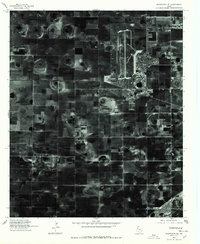 1976 Wolfforth SE1978 Print · USGSLubbock County agricultural and military life are preserved in this 1970s aerial survey. Trace the layout of the airfield at Reese Village and see the early development of Wolfforth amidst a patchwork of center-pivot irrigation fields.
 - 1976 Map of Meadow NE, 1978 Print
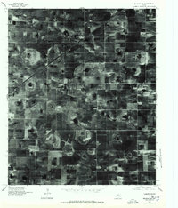 1976 Meadow NE1978 Print · USGSAgricultural patterns dominate the Lubbock County landscape in the mid-seventies, showing the precise grid of West Texas farming. Researchers can locate family operations like the Mc Nabb Farm Airport and trace the evolution of local irrigation systems.
End of results
Showing maps 1-2 of 2
Top cities near Wolfforth
- Lubbock historical maps
- Shallowater historical maps
- New Deal historical maps
- Meadow historical maps
- Smyer historical maps
- Ropesville historical maps
See more
Frequently asked questions
- What are the different types of historical maps available for Wolfforth?
- What is the oldest map of Wolfforth?
- Where can I purchase historical maps of Wolfforth for my home or office?
- Where can I download high-res historical maps of Wolfforth?
- Are there historical topographic maps available for Wolfforth?
- Is there historical aerial imagery available for Wolfforth?
- Where are historical maps of Wolfforth sourced from?