1960s Maps of Mabank, Texas
Explore 4 historic maps of Mabank from the 1960s. These maps offer a rare glimpse into what life looked like during the 1960s — showing old roads, neighborhoods, homes, and landmarks that have changed or disappeared over time.
Whether you're researching your family's past, planning a metal detecting trip, or studying how Mabank's landscape evolved across the 1960s, these high-resolution maps are a powerful tool for exploring the history of this region.
- Focus on a specific era: All maps on this page are from the 1960s, giving you a focused view of this time period.
- See what’s changed: Compare century-old streets, trails, and buildings to today's modern landscape using overlays and satellite layers.
- Research with precision: Use these maps for genealogy, historical research, land use analysis, or educational projects.
- View, download, or print: Maps are fully viewable online in high resolution, and can be downloaded or printed for your own records.
Start exploring Mabank's history through authentic maps from the 1960s. This is your window into the past.
Mabank, TX maps
(4)- 1960 Map of Tool, 1961 Print
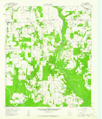 1960 Tool1961 Print · USGSThe rural Henderson County landscape of the early 1960s is preserved here, centered on the creek-fed agricultural lands near the Trinity River. Genealogists and local historians can trace the foundations of Tool, Tolosa, and Aley, alongside family landmarks like Baker Cem and King Cem.3 unique versions available
 - 1960 Map of Mabank, 1961 Print
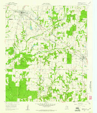 1960 Mabank1961 Print · USGSThe crossroads of Henderson, Kaufman, and Van Zandt counties are captured here in the early sixties, showing a landscape defined by small-town life and the railroad. Genealogists can trace family roots through landmarks like Elam Grove Ch, Mabank Cem, and rural outposts such as Payne Springs.5 unique versions available
 - 1961 Map of Kemp, 1962 Print
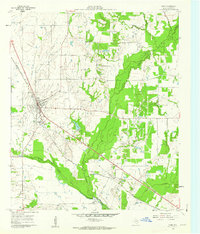 1961 Kemp1962 Print · USGSKaufman County's agricultural and rail landscape is captured here in the early 1960s as infrastructure begins to modernize. Researchers can trace the rail corridors of the Southern Pacific and locate local landmarks like the Cemetery and the small community of Gossett.4 unique versions available
 - 1962 Map of Prairieville, 1965 Print
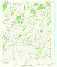 1962 Prairieville1965 Print · USGSThe Van Zandt County countryside comes into focus in the early sixties, showing the rural crossroads and creek-fed farms of the Texas interior. Trace family landmarks like the Aanonsen Cem, Fourmile Ch, and the small settlement at Prairieville.2 unique versions available
End of results
Showing maps 1-4 of 4
Top cities near Mabank
- Athens historical maps
- Kaufman historical maps
- Gun Barrel City historical maps
- Tool historical maps
- Malakoff historical maps
- Kerens historical maps
See more
Frequently asked questions
- What are the different types of historical maps available for Mabank?
- What is the oldest map of Mabank?
- Where can I purchase historical maps of Mabank for my home or office?
- Where can I download high-res historical maps of Mabank?
- Are there historical topographic maps available for Mabank?
- Is there historical aerial imagery available for Mabank?
- Where are historical maps of Mabank sourced from?