Old Maps of Martin County, Texas
Explore 161 old maps of Martin County, spanning from 1941 to today. These high-resolution historic maps reveal how streets, neighborhoods, landmarks, and natural features evolved over time — perfect for genealogy, metal detecting, research, and local history exploration.
What you can do with these maps:
- See how Martin County changed over time: Compare historical maps to modern-day views to trace roads, homesites, rail lines & more.
- View detailed metadata: Each map includes creators, publishers, year, scale, and archive source.
- Overlay maps with satellite & LiDAR: Visualize the past alongside modern tools to explore terrain & human change.
- Trusted historical sources: Maps sourced from the USGS, Library of Congress, and other archives.
- Access maps your way: View online, download high-res files, or order prints for personal or research use.
Start exploring old maps of Martin County to uncover forgotten places, hidden landmarks, and the deep history beneath your feet.
Martin County, TX maps
(161)- 1941 Map of Morita
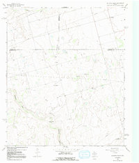
 1941 Morita1941 Print · USGSRanching life and rail transport define this Howard County landscape just before the war. Trace early schools and family holdings like Sandwell Sch, Morita, and Quinn Ranch along the route of the Texas and Pacific railroad.
 - 1949 Map of Morita
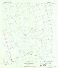
 1949 Morita1949 Print · USGSHoward and Martin Counties in the late 1930s show a landscape of sprawling family ranches and essential rail stops. Genealogists can locate named homesteads like McDowell Ranch and Cross Ranch, or trace the rural students of Sandwell Sch.
 - 1954 Map of Hobbs, 1963 Print
 1954 Hobbs1963 Print · USGSThe High Plains and Permian Basin transition is captured here at the height of the mid-century energy boom. Genealogists and industrial historians can trace the foundations of Humble City, locate the Potash Mine and Plant, and follow the Texas-New Mexico RR.2 unique versions available
 - 1954 Map of Big Spring, 1965 Print
 1954 Big Spring1965 Print · USGSWest Texas in the mid-1950s shows a landscape of growing oil towns and vital rail links along the Texas and Pacific RR. Researchers can trace the development of Big Spring, find smaller settlements like Knott and Lomax, or locate landmarks such as Boyds Chapel and Signal Mountain.4 unique versions available
 - 1958 Map of Big Spring
 1958 Big Spring1958 Print · USGSThe West Texas oil boom was in full swing during the late fifties, transforming the landscape around Howard and Mitchell counties. Genealogists and historians can trace the growth of Big Spring and Snyder alongside industrial landmarks like the Kelly-Snyder Oil Field and the Santa Fe rail lines.
 - 1958 Map of Hobbs
 1958 Hobbs1958 Print · USGSThe High Plains of the Texas-New Mexico border are shown here during the height of the mid-century oil boom. Genealogists and historians can trace the development of Hobbs, Lovington, and Jal, alongside ranching landmarks like James Ranch and the early Texas-New Mexico Railway.
 - 1965 Map of Northeast Midland, 1968 Print
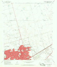 1965 Northeast Midland1968 Print · USGSMid-century Midland is shown during its oil-fueled expansion, where a dense street grid meets the high plains. Researchers can trace family history through neighborhood schools like Fannin Sch or visit the Fairview Cemetery and County Fairground.2 unique versions available
 - 1966 Map of Wolcott Ranch
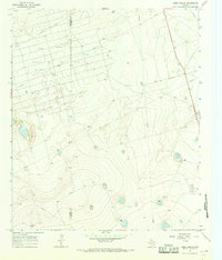
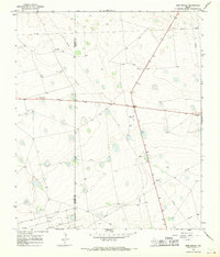
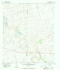
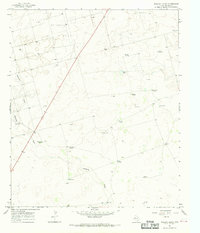 1966 Wolcott Ranch1966 Print · USGSMartin County ranchlands and oil fields are captured here in the mid-sixties during a period of industrial expansion. Local historians can trace the infrastructure of the Breedlove Oil Field and find family-named landmarks like Wolcott Ranch and the Budwizer Windmill.
 - 1966 Map of Knott, 1968 Print
 1966 Knott1968 Print · USGSHoward and Martin Counties in the mid-1960s were defined by a sprawling energy landscape and isolated ranching outposts. Trace the early development of the Knott area through its network of Oil Wells, pipelines, and local landmarks like the Gravel Pit.2 unique versions available
 - 1966 Map of Merrick, 1968 Print
 1966 Merrick1968 Print · USGSMartin County in the mid-1960s was a landscape defined by ranching and the emerging oil industry. Genealogists and researchers can trace local landmarks like the West Nebel Mission and the small settlements of Flower Grove and Merrick.
 - 1966 Map of Lenorah West, 1968 Print
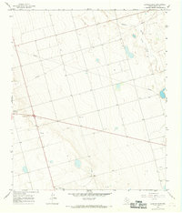
 1966 Lenorah West1968 Print · USGSThe Texas High Plains of Martin County are captured in the mid-1960s, showing the early infrastructure of the Permian Basin. Genealogists and local historians can trace the rural layouts of Tarzan, Grady, and Lenorah along the Mustang Draw drainage.
 - 1966 Map of Mabee Ranch, 1968 Print
 1966 Mabee Ranch1968 Print · USGSThe West Texas plains in the mid-sixties show the heavy footprint of the energy industry along the border of Andrews and Martin counties. Researchers can trace the development of the Mabee Oil Field through its pumping station, pipelines, and the historic Mabee Ranch.2 unique versions available
 - 1966 Map of Flynt Ranch, 1968 Print
 1966 Flynt Ranch1968 Print · USGSMartin County rangeland in the mid-1960s reveals a landscape defined by ranching and the rising oil industry. Researchers can trace land use through named features like Flynt Ranch, Quick Trigger Windmill, and the extensive PIPELINE network.
 - 1966 Map of Flower Grove, 1968 Print
 1966 Flower Grove1968 Print · USGSFlower Grove and the West Texas plains appear in the mid-1960s as a landscape of energy exploration and cattle ranching. Trace early oil and gas development through features like the Soda Windmills, Drill Hole, and the settlement at Three League.
 - 1966 Map of Natural Dam Lake, 1968 Print
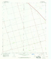
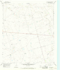
 1966 Natural Dam Lake1968 Print · USGSHoward and Martin Counties in the mid-1960s are defined by the intersection of industrial development and salt basin hydrology. Researchers can trace the Texas and Pacific rail line through Morita and locate numerous wells and Gravel Pits.2 unique versions available
 - 1966 Map of Scharbauer Ranch, 1968 Print
 1966 Scharbauer Ranch1968 Print · USGSThe high plains of the Permian Basin come into focus during the mid-sixties, showing the intersection of cattle ranching and the oil industry. Researchers can trace land use through landmarks like Scharbauer Ranch, Mustang Draw, and Old L 7 Ranch.
 - 1966 Map of Bird Ranch, 1968 Print
 1966 Bird Ranch1968 Print · USGSThe West Texas plains at the border of Andrews and Martin counties come into focus during the mid-sixties energy boom. Researchers can trace petroleum infrastructure like the Mabee Oil Field alongside local landmarks such as Bird Ranch and Glass.
 - 1966 Map of Germania, 1968 Print
 1966 Germania1968 Print · USGSMid-1960s West Texas comes alive along the boundary of Martin and Midland counties as the oil industry shapes the landscape. Trace the diagonal route of the Texas and Pacific railroad through the settlements of Germania and Greenwood.2 unique versions available
 - 1966 Map of Houston Ranch, 1968 Print
 1966 Houston Ranch1968 Print · USGSThe West Texas plains at the meeting of Glasscock, Howard, and Martin counties are captured here in the mid-sixties. Researchers can trace ranching and oil history through the Old Houston Place, the Lomax settlement, and the landmark Hog Mountain.2 unique versions available
 - 1966 Map of North Curtis Ranch, 1968 Print
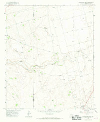
 1966 North Curtis Ranch1968 Print · USGSMartin County ranching life in the mid-sixties centered on isolated outposts and vital water sources scattered across the High Plains. Genealogists and historians can trace the local landscape through family-named landmarks like Kelton Windmill, Glass Ranch, and Mott Windmill.
 - 1966 Map of Stanton, 1968 Print
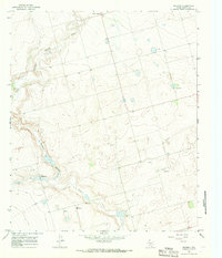
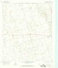
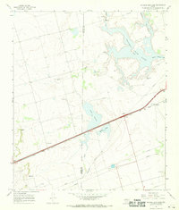
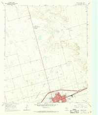 1966 Stanton1968 Print · USGSStanton and the surrounding Martin County plains are captured in the mid-1960s as the local economy balanced rail transport and oil production. Genealogists and researchers can locate the Convent, the Hospital, and trace the path of the Texas and Pacific railroad.
 - 1966 Map of Northwest Midland, 1968 Print
 1966 Northwest Midland1968 Print · USGSMidland expands northward during the mid-sixties, showcasing a landscape where local ranching and early suburban growth meet. Trace the development of neighborhood schools like Lee High Sch, the Drive-in Theater, and the unique High Sky Girls Ranch.3 unique versions available
 - 1966 Map of Knott SW, 1969 Print
 1966 Knott SW1969 Print · USGSThe West Texas oil fields and rural schools of the Permian Basin come into focus during the mid-sixties. Researchers can trace the development of the Varel Field and locate community landmarks like Hartwell School and Lakeview Ch.2 unique versions available
 - 1966 Map of Dickenson Ranch, 1969 Print
 1966 Dickenson Ranch1969 Print · USGSMartin County ranching and energy production are captured here in the mid-sixties. Researchers can trace historic family-named water sources like Rattlesnake Windmill or Williams Windmill and the early industrial footprint of the Gas Well near Courtney.
 - 1966 Map of Lenorah East, 1969 Print
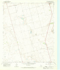
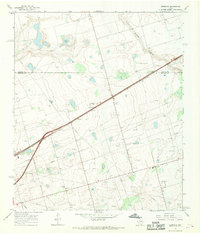
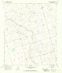
 1966 Lenorah East1969 Print · USGSThe West Texas plains of Martin County are captured here in the mid-sixties as the local economy balanced ranching with oil extraction. Researchers can locate the community of Lenorah, trace the route of Sulphur Springs Draw, and find early petroleum sites like Oil Wells.
Showing maps 1-25 of 161
Top cities of Martin County
Frequently asked questions
- What are the different types of historical maps available for Martin County?
- What is the oldest map of Martin County?
- Where can I purchase historical maps of Martin County for my home or office?
- Where can I download high-res historical maps of Martin County?
- Are there historical topographic maps available for Martin County?
- Is there historical aerial imagery available for Martin County?
- Where are historical maps of Martin County sourced from?