1990s Maps of Matagorda County, Texas
Explore 10 historic maps of Matagorda County from the 1990s. These maps offer a rare glimpse into what life looked like during the 1990s — showing old roads, neighborhoods, homes, and landmarks that have changed or disappeared over time.
Whether you're researching your family's past, planning a metal detecting trip, or studying how Matagorda County's landscape evolved across the 1990s, these high-resolution maps are a powerful tool for exploring the history of this region.
- Focus on a specific era: All maps on this page are from the 1990s, giving you a focused view of this time period.
- See what’s changed: Compare century-old streets, trails, and buildings to today's modern landscape using overlays and satellite layers.
- Research with precision: Use these maps for genealogy, historical research, land use analysis, or educational projects.
- View, download, or print: Maps are fully viewable online in high resolution, and can be downloaded or printed for your own records.
Start exploring Matagorda County's history through authentic maps from the 1990s. This is your window into the past.
Matagorda County, TX maps
(10)- 1994 Map of El Campo
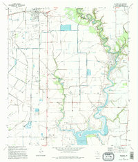
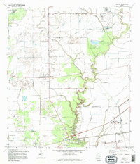
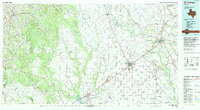 1994 El Campo1994 Print · USGSCoastal Texas in the mid-nineties shows a landscape deeply shaped by the energy industry and rail logistics. Researchers can trace the sprawling Sheridan Gas Field or locate historic rail stops in El Campo, Spanish Camp, and Provident City.
 - 1995 Map of Palacios NE
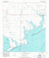
 1995 Palacios NE1995 Print · USGSThe Matagorda County coastline comes alive in the mid-nineties, showing the delicate balance between the industrial gas fields and protected coastal marshes. Researchers can trace the Old RR Grade near Citrus Grove or explore the intricate waterways of Robbins Slough and the Mad Island Wildlife Management Area.
 - 1995 Map of Blessing SE
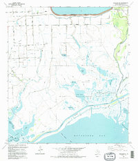
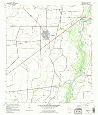
 1995 Blessing SE1995 Print · USGSThe Matagorda County coastline was a hub of energy and industry in the mid-nineties, balancing heavy utility development with the winding Colorado River. Researchers can trace the legacy of early settlements at Ashby (Site) or locate landmarks like St Mary Ch and the Port of Bay City.
 - 1995 Map of Palacios
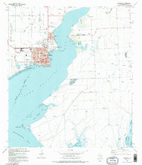 1995 Palacios1995 Print · USGSCoastal life in Matagorda County centers on the bayfront in the 1990s, where the city of Palacios meets the tide. Genealogists and researchers can map out the town grid or locate outlying landmarks like the Collegeport Cem and the Fish Hatchery.
 - 1995 Map of Blessing
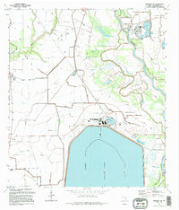
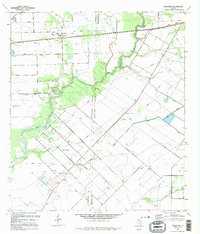
 1995 Blessing1995 Print · USGSThe coastal prairie of Matagorda County is captured here in the mid-1990s, where the Tres Palacios River meets the bay. Genealogists and local historians can locate several rural burial sites, including Grimes Cem and Ashby Cem, or trace the path of the Old Railroad Grade.
 - 1995 Map of Francitas NE
 1995 Francitas NE1995 Print · USGSThe coastal prairies of Jackson and Matagorda counties are shown in the mid-1990s as a hub of energy production and water management. Researchers can trace historical county line disputes and industrial sites like the Mauritz Oil Field and North Francitas Oil Field.
 - 1995 Map of Francitas
 1995 Francitas1995 Print · USGSThe coastal prairie of Matagorda and Jackson counties appears here in the mid-1990s, characterized by oil production and rural life. Researchers can trace family sites near Francitas and Deutschburg, and locate the Francitas Cem or the local Landing Strip.
 - 1995 Map of Markham
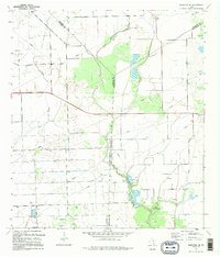
 1995 Markham1995 Print · USGSCoastal Texas prairie and petroleum industry meet along the Colorado River during the mid-nineties. Researchers can trace the legacy of local extraction at the North Markham Oil Field or locate vanished rail infrastructure along the Old Railroad Grade.
 - 1995 Map of Turtle Bay
 1995 Turtle Bay1995 Print · USGSThe Texas Gulf Coast near the Jackson and Matagorda county lines is captured here in the mid-nineties as aquaculture and coastal communities shaped the shore. Trace family footprints in the Schicke Point Community or study the marshes around Buttermilk Slough and Sartwelle Lakes.
 - 1995 Map of Midfield
 1995 Midfield1995 Print · USGSCoastal Texas prairies in the 1990s show a landscape of river-fed agriculture and energy production. Genealogists can trace family names at Hawley Cem or Lacy Cem, while researchers can locate rural centers like Midfield and Clemville.
End of results
Showing maps 1-10 of 10
Top cities of Matagorda County
Frequently asked questions
- What are the different types of historical maps available for Matagorda County?
- What is the oldest map of Matagorda County?
- Where can I purchase historical maps of Matagorda County for my home or office?
- Where can I download high-res historical maps of Matagorda County?
- Are there historical topographic maps available for Matagorda County?
- Is there historical aerial imagery available for Matagorda County?
- Where are historical maps of Matagorda County sourced from?