1980s Maps of Matagorda County, Texas
Explore 4 historic maps of Matagorda County from the 1980s. These maps offer a rare glimpse into what life looked like during the 1980s — showing old roads, neighborhoods, homes, and landmarks that have changed or disappeared over time.
Whether you're researching your family's past, planning a metal detecting trip, or studying how Matagorda County's landscape evolved across the 1980s, these high-resolution maps are a powerful tool for exploring the history of this region.
- Focus on a specific era: All maps on this page are from the 1980s, giving you a focused view of this time period.
- See what’s changed: Compare century-old streets, trails, and buildings to today's modern landscape using overlays and satellite layers.
- Research with precision: Use these maps for genealogy, historical research, land use analysis, or educational projects.
- View, download, or print: Maps are fully viewable online in high resolution, and can be downloaded or printed for your own records.
Start exploring Matagorda County's history through authentic maps from the 1980s. This is your window into the past.
Matagorda County, TX maps
(4)- 1980 Map of Carancahua Pass, 1981 Print
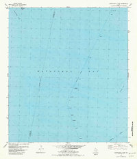 1980 Carancahua Pass1981 Print · USGSThe coastal waters of Matagorda Bay are captured here in the early eighties, revealing the vital shipping lanes of the Texas Gulf. Researchers can trace the maritime navigation of Palacios Channel and the precise location of Halfmoon Reef.
 - 1983 Map of San Antonio Bay
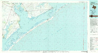 1983 San Antonio Bay1983 Print · USGSThe Texas Coastal Bend in the early eighties is a landscape of expansive estuaries and barrier islands. Local historians can trace the development of Port O'Connor and Seadrift, the boundaries of the Aransas National Wildlife Refuge, and the path of an Old RR Grade near Tivoli.
 - 1984 Map of Port Lavaca
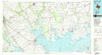 1984 Port Lavaca1984 Print · USGSCoastal Texas in the mid-1980s reveals a landscape of industrial waterways and historic rail corridors. Genealogists and historians can trace family roots through settlements like Bloomington and La Ward or explore the transit networks of the Southern Pacific and Missouri Pacific.
 - 1984 Map of Angleton
 1984 Angleton1984 Print · USGSThe Texas Gulf Coast in the mid-eighties shows a landscape of salt domes and bayous at the height of its oil-and-river economy. Researchers can trace land use through the Damon Mound Oil Field and the sprawling State Department of Corrections (Retrieve Unit).2 unique versions available
End of results
Showing maps 1-4 of 4
Top cities of Matagorda County
Frequently asked questions
- What are the different types of historical maps available for Matagorda County?
- What is the oldest map of Matagorda County?
- Where can I purchase historical maps of Matagorda County for my home or office?
- Where can I download high-res historical maps of Matagorda County?
- Are there historical topographic maps available for Matagorda County?
- Is there historical aerial imagery available for Matagorda County?
- Where are historical maps of Matagorda County sourced from?