1900s (20th Century) Maps of Brady, Texas
Explore 6 historic maps of Brady from the 1900s (20th Century). These maps offer a rare glimpse into what life looked like during the 1900s — showing old roads, neighborhoods, homes, and landmarks that have changed or disappeared over time.
Whether you're researching your family's past, planning a metal detecting trip, or studying how Brady's landscape evolved across the 1900s, these high-resolution maps are a powerful tool for exploring the history of this region.
- Focus on a specific era: All maps on this page are from the 1900s, giving you a focused view of this time period.
- See what’s changed: Compare century-old streets, trails, and buildings to today's modern landscape using overlays and satellite layers.
- Research with precision: Use these maps for genealogy, historical research, land use analysis, or educational projects.
- View, download, or print: Maps are fully viewable online in high resolution, and can be downloaded or printed for your own records.
Start exploring Brady's history through authentic maps from the 1900s. This is your window into the past.
Brady, TX maps
(6)- 1954 Map of Brownwood, 1955 Print
 1954 Brownwood1955 Print · USGSCentral Texas in the early fifties shows a landscape of rail-linked cattle towns and winding river valleys before modern highway expansion. Genealogists and historians can trace family-named peaks and vanished rail stops like Trickham, Santa Anna, and the Brady Mountains.3 unique versions available
 - 1960 Map of West Sweden, 1961 Print
 1960 West Sweden1961 Print · USGSMcCulloch County in the early sixties shows a landscape of cattle ranching and rail commerce at the base of the Brady Mountains. Researchers can trace the Gulf Colorado and Santa Fe line through Niblock or locate the Carroll Colony Cem near the banks of Bowie Creek.2 unique versions available
 - 1960 Map of Brady North, 1961 Print
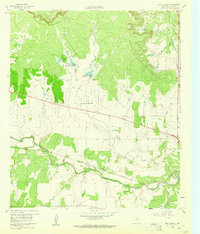
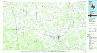
 1960 Brady North1961 Print · USGSBrady and the surrounding McCulloch County hills are captured here in the early sixties as a center of Texas ranching and rail. Genealogists can locate family landmarks like Rest Haven Cem, Live Oak Cem, and the community of East Sweden.3 unique versions available
 - 1963 Map of Brady SW, 1964 Print
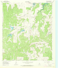 1963 Brady SW1964 Print · USGSMcCulloch County was undergoing significant water management in the early sixties as new impoundments shaped the ranch land. Trace the early spillways and creek beds of Brady Reservoir, Reservoir No 5, and Post Oak Creek.2 unique versions available
 - 1970 Map of Brady South, 1973 Print
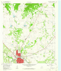
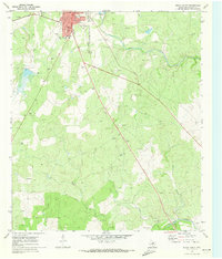 1970 Brady South1973 Print · USGSMcCulloch County in the early seventies shows the southward expansion of Brady toward the San Saba River. Researchers can trace old rail lines like the Atchison Topeka and Santa Fe or locate the rural South China Sch.2 unique versions available
 - 1985 Map of Brady
 1985 Brady1985 Print · USGSMcCulloch and Concho counties during the mid-1980s show a landscape of small ranching communities tied together by the Atchison Topeka and Santa Fe rail line. Researchers can trace rural developments like West Sweden, Pear Valley, and the waters of the Brady Reservoir.2 unique versions available
End of results
Showing maps 1-6 of 6
Top cities near Brady
Top neighborhoods of Brady
Frequently asked questions
- What are the different types of historical maps available for Brady?
- What is the oldest map of Brady?
- Where can I purchase historical maps of Brady for my home or office?
- Where can I download high-res historical maps of Brady?
- Are there historical topographic maps available for Brady?
- Is there historical aerial imagery available for Brady?
- Where are historical maps of Brady sourced from?