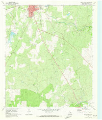
1970 Map of Brady South
USGS Topo · Published 1973About this map
The northern edge of this McCulloch County survey is anchored by the southern expansion of Brady, showing the town's residential growth around Stanburn Park and the municipal Hospital. The landscape transitions from these developed blocks into a vast network of drainage systems, including Post Oak Creek, Slaton Creek, and Brady Creek, all flowing toward the southern border. This area is characterized by a significant extractive industry, with numerous Gravel Pits dotting the terrain between the creeks. Historical infrastructure is visible in the alignment of the Atchison Topeka and Santa Fe railroad cutting through the center, while the rural heritage of the county is evidenced by the presence of the South China Sch located along the eastern hills. The map concludes at the San Saba River, where a public Picnic Area marks the riverbank in the southeast corner.
Find a feature on this map
18 named features on this map. Tap any name to fly to it.
Don’t see what you’re looking for? This feature index may not catch every label — zoom into the map to look around manually.
Map Details
Editions of this 1970 Brady South Map
2 editions found
Other maps of this area

1887 · Mason
USGS Topo · 1:125,000

1894 · Brady
USGS Topo · 1:125,000

1894 · Mason
USGS Topo · 1:125,000

1954 · Brownwood
USGS Topo · 1:250,000

1954 · Llano
USGS Topo · 1:250,000

1955 · Llano
USGS Topo · 1:250,000

1956 · Llano
USGS Topo · 1:250,000

1960 · West Sweden
USGS Topo · 1:24,000

1960 · Brady North
USGS Topo · 1:24,000

1963 · Spy Rock
USGS Topo · 1:24,000