
Loading...
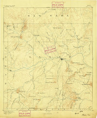
Loading map...1956 Map of Llano
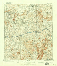
USGS Topo · Published 1976About this map
The Colorado River and its massive impoundments, including Lake Buchanan and Lake Lyndon B Johnson, dominate the eastern landscape of the Texas Hill Country in this mid-1970s revision. This area highlights a critical period of regional development where traditional ranching settlements like Castell and Luckenbach exist alongside growing recreation hubs at Inks Lake State Park and Longhorn Cavern State Park.
Find a feature on this map
104 named features on this map. Tap any name to fly to it.
Don’t see what you’re looking for? This feature index may not catch every label — zoom into the map to look around manually.
Map Details
Date Portrayed1956
Date Published1976
PublisherU.S. Geological Survey
Map TypeTopographic
Scale1:250,000
Physical Dimensions33.6 x 22.2 inches
Editions of this 1956 Llano Map
This is the sole edition of this map. No revisions or reprints were ever made.
Historical Maps of Kerrville Through Time
10 maps found


Featured Locations
Source Details
SourceU.S. Geological Survey
CopyrightPublic Domain