1920s Maps of Fife, Texas
Explore 2 historic maps of Fife from the 1920s. These maps offer a rare glimpse into what life looked like during the 1920s — showing old roads, neighborhoods, homes, and landmarks that have changed or disappeared over time.
Whether you're researching your family's past, planning a metal detecting trip, or studying how Fife's landscape evolved across the 1920s, these high-resolution maps are a powerful tool for exploring the history of this region.
- Focus on a specific era: All maps on this page are from the 1920s, giving you a focused view of this time period.
- See what’s changed: Compare century-old streets, trails, and buildings to today's modern landscape using overlays and satellite layers.
- Research with precision: Use these maps for genealogy, historical research, land use analysis, or educational projects.
- View, download, or print: Maps are fully viewable online in high resolution, and can be downloaded or printed for your own records.
Start exploring Fife's history through authentic maps from the 1920s. This is your window into the past.
Fife, TX maps
(2)- 1925 Map of Brady 2-b
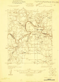 1925 Brady 2-b1925 Print · USGSMcCulloch County during the mid-1920s reveals a landscape defined by the serpentine bends of the Colorado River and scattered rural communities. Genealogists and historians can locate specific sites like Marion School, Chaffin Cem, and the river transit point at Chaffin Crossing.
 - 1928 Map of Waldrip
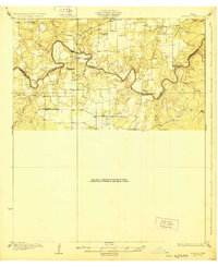 1928 Waldrip1928 Print · USGSCrossing the Colorado River in the late 1920s, this area of McCulloch and Coleman Counties was a landscape of remote ranches and vital river fords. Genealogists can locate family landmarks like Chaffin Cem and White Ranch or trace old routes through Military Crossing.2 unique versions available
End of results
Showing maps 1-2 of 2
Top cities near Fife
Frequently asked questions
- What are the different types of historical maps available for Fife?
- What is the oldest map of Fife?
- Where can I purchase historical maps of Fife for my home or office?
- Where can I download high-res historical maps of Fife?
- Are there historical topographic maps available for Fife?
- Is there historical aerial imagery available for Fife?
- Where are historical maps of Fife sourced from?