1960s Maps of Valley Ranch, Texas
Explore 2 historic maps of Valley Ranch from the 1960s. These maps offer a rare glimpse into what life looked like during the 1960s — showing old roads, neighborhoods, homes, and landmarks that have changed or disappeared over time.
Whether you're researching your family's past, planning a metal detecting trip, or studying how Valley Ranch's landscape evolved across the 1960s, these high-resolution maps are a powerful tool for exploring the history of this region.
- Focus on a specific era: All maps on this page are from the 1960s, giving you a focused view of this time period.
- See what’s changed: Compare century-old streets, trails, and buildings to today's modern landscape using overlays and satellite layers.
- Research with precision: Use these maps for genealogy, historical research, land use analysis, or educational projects.
- View, download, or print: Maps are fully viewable online in high resolution, and can be downloaded or printed for your own records.
Start exploring Valley Ranch's history through authentic maps from the 1960s. This is your window into the past.
Valley Ranch, TX maps
(2)- 1961 Map of Moonshine Hill, 1962 Print
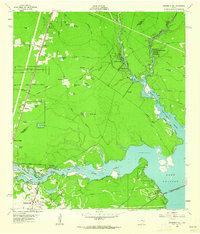 1961 Moonshine Hill1962 Print · USGSHarris and Montgomery counties appear at a crossroads in the early sixties as oil production and suburban growth meet the San Jacinto riverfront. Researchers can trace family roots at White Oak Cem, locate the wells of Riverside Field, or find early subdivisions like Walden Woods.4 unique versions available
 - 1961 Map of Maedan, 1962 Print
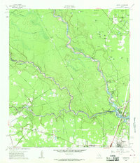 1961 Maedan1962 Print · USGSThe Montgomery and Harris County borderlands come alive in this early 1960s survey, showing the confluence of river bottomlands and emerging rail-side communities. Trace the roots of Bordersville and Maedan or locate family markers at Enloe Cem and Tetter Cem.2 unique versions available
End of results
Showing maps 1-2 of 2
Top cities near Valley Ranch
- Houston historical maps
- The Woodlands historical maps
- Conroe historical maps
- Atascocita historical maps
- Kingwood historical maps
- Spring historical maps
See more
Top neighborhoods of Valley Ranch
- Valley Ranch Town Center historical maps
- Valley Ranch historical maps
- Azalea District historical maps
- Forest Colony historical maps
Frequently asked questions
- What are the different types of historical maps available for Valley Ranch?
- What is the oldest map of Valley Ranch?
- Where can I purchase historical maps of Valley Ranch for my home or office?
- Where can I download high-res historical maps of Valley Ranch?
- Are there historical topographic maps available for Valley Ranch?
- Is there historical aerial imagery available for Valley Ranch?
- Where are historical maps of Valley Ranch sourced from?